Lexington County, South Carolina
| Lexington County, South Carolina | |
|---|---|

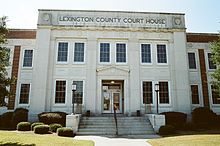
Lexington County Courthouse in October 2013
|
|
| Motto: In God We Trust | |
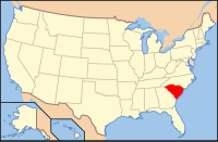
 Location in the U.S. state of South Carolina |
|
 South Carolina's location in the U.S. |
|
| Founded | 1785 |
| Named for | Battle of Lexington and Concord |
| Seat | Lexington |
| Largest town | Lexington |
| Area | |
| • Total | 758 sq mi (1,963 km2) |
| • Land | 699 sq mi (1,810 km2) |
| • Water | 59 sq mi (153 km2), 7.8% |
| Population (est.) | |
| • (2016) | 286,186 |
| • Density | 375/sq mi (145/km²) |
| Congressional district | 2nd |
| Time zone | Eastern: UTC-5/-4 |
| Website | www |
Lexington County is a county located in the U.S. state of South Carolina. As of the 2010 census, the population was 262,391, and the 2016 population estimate was 286,186. Its county seat and largest town is Lexington. The county was created in 1785. Its name commemorates the Battle of Lexington in the American Revolutionary War.
Lexington County is part of the Columbia, SC Metropolitan Statistical Area.
According to the U.S. Census Bureau, the county has a total area of 758 square miles (1,960 km2), of which 699 square miles (1,810 km2) is land and 59 square miles (150 km2) (7.8%) is water. The largest body of water is Lake Murray. While other waterways include Broad River, Saluda River and Congaree River
Lexington County, SC, gets 48 inches of rain per year. The US average is 37. Snowfall is 2 inches. The average US city gets 25 inches of snow per year. The number of days with any measurable precipitation is 104.
On average, there are 218 sunny days per year in Lexington County, SC. The July high is around 92 degrees. The January low is 33. The comfort index, which is based on humidity during the hot months, is a 29 out of 100, where higher is more comfortable. The US average on the comfort index is 44.
As of the census of 2000, there were 216,014 people, 83,240 households, and 59,849 families residing in the county. The population density was 309 people per square mile (119/km²). There were 90,978 housing units at an average density of 130 per square mile (50/km²). The racial makeup of the county was 84.18% White, 12.63% Black or African American, 0.34% Native American, 1.05% Asian, 0.04% Pacific Islander, 0.79% from other races, and 0.98% from two or more races. 1.92% of the population were Hispanic or Latino of any race.
...
Wikipedia
