Greenville-Spartanburg-Anderson Combined Statistical Area
| Greenville CSA | |
|---|---|
| CSA | |
| Greenville–Spartanburg–Anderson, SC Combined Statistical Area | |

Greenville skyline
|
|
|
Greenville–Anderson–Mauldin Metropolitan Statistical Area
Spartanburg Metropolitan Statistical Area
Greenwood Micropolitan Statistical Area
Seneca Micropolitan Statistical Area
Gaffney Micropolitan Statistical Area
|
|
| Country |
|
| State |
|
| Principal cities |
Greenville Spartanburg Anderson Mauldin Easley |
| Area | |
| • Total | 6,168 sq mi (15,980 km2) |
| • Land | 6,027 sq mi (15,610 km2) |
| • Water | 141 sq mi (370 km2) 2.2% |
| Population (2014) | |
| • CSA | 1,409,582(40th) |
| Time zone | EST |
| • Summer (DST) | EDT (UTC) |
| Area code(s) | 864 |
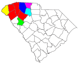
The Upstate is the region in the westernmost part of South Carolina, United States, also known as the Upcountry, which is the historical term. Although loosely defined among locals, the general definition includes the ten counties of the commerce-rich I-85 corridor in the northwest corner of South Carolina. This definition coincides with the Greenville–Spartanburg–Anderson, SC Combined Statistical Area, as defined by the Office of Management and Budget in 2015. The region's population was 1,409,582 as of 2014. Situated between Atlanta and Charlotte, the Upstate is the fastest-growing region of South Carolina. After BMW's initial investment, foreign companies, including others from Germany, have a substantial presence in the Upstate; several large corporations have established regional, national, or continental headquarters in the area. Greenville is the largest city in the region with a population of 67,453 and an urban-area population of 400,492, and it is the base of most commercial activity. Spartanburg, followed by Anderson, are next in population.
Ten counties are included in the Upstate of South Carolina: Greenville, Spartanburg, Anderson, Pickens, Cherokee, Oconee, Union, Laurens, Greenwood, and Abbeville.
...
Wikipedia

