Mauldin, South Carolina
| Mauldin, South Carolina | |
|---|---|
| City | |

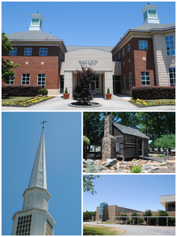
Top, left to right: Mauldin City Hall, Mauldin United Methodist Church, Mauldin Cultural Center, Mauldin High School
|
|
 Location of Mauldin, South Carolina |
|
| Coordinates: 34°46′51″N 82°18′2″W / 34.78083°N 82.30056°WCoordinates: 34°46′51″N 82°18′2″W / 34.78083°N 82.30056°W | |
| Country | United States |
| State | South Carolina |
| County | Greenville |
| Area | |
| • Total | 10.0 sq mi (25.9 km2) |
| • Land | 10.0 sq mi (25.8 km2) |
| • Water | 0.04 sq mi (0.1 km2) |
| Elevation | 951 ft (290 m) |
| Population (2010) | |
| • Total | 22,889 |
| • Estimate (2015) | 25,135 |
| • Density | 2,525/sq mi (975.0/km2) |
| Time zone | Eastern (EST) (UTC-5) |
| • Summer (DST) | EDT (UTC-4) |
| ZIP code | 29662 |
| Area code(s) | 864 |
| FIPS code | 45-45115 |
| GNIS feature ID | 1246563 |
| Website | www |
Mauldin is a city in Greenville County, South Carolina, United States. The population was 15,224 at the 2000 census, 22,889 at the 2010 census, and an estimated 25,135 in 2015. It is a principal city of the Greenville-Anderson-Mauldin Metropolitan Statistical Area.
Mauldin is located south of the center of Greenville County, between the city of Greenville to the northwest and Simpsonville to the southeast. According to the United States Census Bureau, the city has a total area of 10.0 square miles (25.9 km2), of which 0.04 square miles (0.1 km2), or 0.46%, are water.
U.S. Route 276 (Main Street) passes through the center of Mauldin, leading northwest 8 miles (13 km) to the center of Greenville and southeast 5 miles (8 km) to Simpsonville. Interstate 385 runs through the eastern side of Mauldin, leading north to Interstate 85 on the east side of Greenville. I-385 connects with Interstate 185 on the southern edge of Mauldin, and I-185 continues west and northwest 13 miles (21 km) to join I-85 on the southwest side of Greenville. From its interchange with I-185, I-385 leads southeast 30 miles (48 km) to Interstate 26 near Clinton.
Benjamin Griffith was awarded the first land grant in what is now called Mauldin in 1784. The name of Mauldin was given to the town almost accidentally in 1820 thanks to South Carolina's lieutenant governor, W. L. Mauldin. The train station was called "Mauldin" because the lieutenant governor had assisted in getting the Greenville Laurens Railroad Company to come through the village. Over time, the entire area took the name of Mauldin.
...
Wikipedia
