Simpsonville, South Carolina
| Simpsonville, South Carolina | |
|---|---|
| City | |

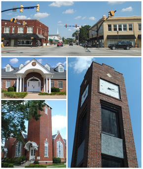
From top, left to right: Downtown, City Hall, Simpsonville Baptist Church, Simpsonville Clock Tower
|
|
| Motto: "Character Protected, Community Perfected" | |
 Location of Simpsonville, South Carolina |
|
| Coordinates: 34°44′0″N 82°15′36″W / 34.73333°N 82.26000°WCoordinates: 34°44′0″N 82°15′36″W / 34.73333°N 82.26000°W | |
| Country | United States |
| State | South Carolina |
| County | Greenville |
| Government | |
| • Mayor | Janice Curtis |
| Area | |
| • Total | 8.83 sq mi (22.88 km2) |
| • Land | 8.81 sq mi (22.82 km2) |
| • Water | 0.02 sq mi (0.06 km2) |
| Elevation | 860 ft (262 m) |
| Population (2010) | |
| • Total | 18,238 |
| • Density | 2,070/sq mi (799.4/km2) |
| Time zone | Eastern (EST) (UTC-5) |
| • Summer (DST) | EDT (UTC-4) |
| ZIP codes | 29680-29681 |
| Area code(s) | 864 |
| FIPS code | 45-66580 |
| GNIS feature ID | 1250898 |
| Website | www |
Simpsonville is a city in Greenville County, South Carolina, United States. It is part of the Greenville–Mauldin–Easley Metropolitan Statistical Area. The population was 18,238 at the 2010 census, up from 14,352 at the 2000 census. The population had risen to an estimated 20,736 as of 2015. Simpsonville is part of the "Golden Strip", along with Mauldin and Fountain Inn, an area which is noted for having low unemployment due to a diversity of industries including Para-Chem, Kemet, Sealed Air and Milliken.
The Burdette Building, Cureton-Huff House, Hopkins Farm, and Simpsonville Baptist Church are listed on the National Register of Historic Places.
Simpsonville is located in southeastern Greenville County at 34°44′0″N 82°15′36″W / 34.73333°N 82.26000°W (34.733375, -82.260001), between Mauldin to the northwest and Fountain Inn to the southeast. The center of town has an elevation of 866 feet (264 m) above sea level.
...
Wikipedia
