Fountain Inn, South Carolina
| Fountain Inn, South Carolina | |
|---|---|
| City | |

Top, left to right: Downtown Fountain Inn, Fountain Inn City Hall, Cannon Building, Fairview Presbyterian Church, Robert Quillen Office and Library
|
|
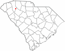
 Location of Fountain Inn, South Carolina |
|
| Coordinates: 34°41′36″N 82°11′55″W / 34.69333°N 82.19861°WCoordinates: 34°41′36″N 82°11′55″W / 34.69333°N 82.19861°W | |
| Country | United States |
| State | South Carolina |
| Counties | Greenville, Laurens |
| Area | |
| • Total | 7.9 sq mi (20.5 km2) |
| • Land | 7.9 sq mi (20.4 km2) |
| • Water | 0.04 sq mi (0.1 km2) |
| Elevation | 866 ft (264 m) |
| Population (2010) | |
| • Total | 7,799 |
| • Density | 989/sq mi (381.8/km2) |
| Time zone | Eastern (EST) (UTC-5) |
| • Summer (DST) | EDT (UTC-4) |
| ZIP code | 29644 |
| Area code(s) | 864 |
| FIPS code | 45-27070 |
| GNIS feature ID | 1222514 |
| Website | www |
Fountain Inn is a city in Greenville and Laurens counties in the U.S. state of South Carolina. The population was 7,799 at the 2010 census, up from 6,017 at the 2000 census. It is part of the Greenville–Mauldin–Easley Metropolitan Statistical Area.
The Cannon Building, Fairview Presbyterian Church, Fountain Inn High School, Fountain Inn Principal's House and Teacherage, McDowell House, Robert Quillen Office and Library, Tullyton, and F. W. Welborn House are listed on the National Register of Historic Places.
The southern part of the city is in Laurens County, while the bulk of the city is in Greenville County. The city's nickname is "The Diamond Tip of the Golden Strip". The city took its name from an inn and fountain that were along the old stagecoach route. The stagecoach drivers called the stop "Fountain Inn", and it stuck. A small garden fountain is installed at City Hall, and there is a marker on the north side of town showing the former location of the old inn.
...
Wikipedia
