Pickens County, South Carolina
| Pickens County, South Carolina | |
|---|---|

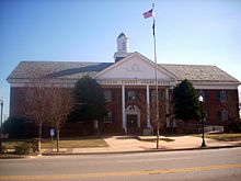
Pickens County Courthouse
|
|
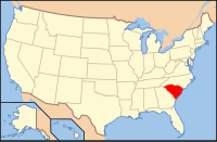
 Location in the U.S. state of South Carolina |
|
 South Carolina's location in the U.S. |
|
| Founded | 1826 |
| Named for | Andrew Pickens |
| Seat | Pickens |
| Largest city | Easley |
| Area | |
| • Total | 512 sq mi (1,326 km2) |
| • Land | 496 sq mi (1,285 km2) |
| • Water | 16 sq mi (41 km2), 3.1% |
| Population (est.) | |
| • (2015) | 121,691 |
| • Density | 240/sq mi (93/km²) |
| Congressional district | 3rd |
| Time zone | Eastern: UTC-5/-4 |
| Website | www |
Pickens County is a county in the northwest part of the U.S. state of South Carolina. As of the 2010 census, its population was 119,224. Its county seat is Pickens. The county was created in 1826.
It is part of the Greenville-Anderson-Mauldin, SC Metropolitan Statistical Area.
Pickens County was Cherokee Indian Territory until the American Revolution. The Cherokees sided with the British, suffered defeat, and surrendered their South Carolina lands. This former Cherokee territory was included in the Ninety-Six Judicial District. In 1791 the state legislature established Washington District, a judicial area composed of present-day Greenville, Anderson, Pickens, and Oconee counties, and then composed of Greenville and Pendleton counties. Streets for the courthouse town of Pickensville (near present-day Easley) were laid off, and soon a cluster of buildings arose that perhaps included a large wooden hotel, which served as a stagecoach stop. In 1798 Washington District was divided into Greenville and Pendleton districts. The latter included what eventually became Anderson, Oconee, and Pickens counties. A new courthouse was erected at Pendleton to accommodate the Court of General Sessions and Common Pleas, and soon thereafter Pickensville began to decline.
In view of the growing population and poor transportation facilities in Pendleton District, the legislature divided it into counties in 1826, and a year later decided instead to divide the area into districts. The legislation went into effect in 1828. The lower part became Anderson and the upper Pickens, named in honor of the Revolutionary soldier, Brigadier General Andrew Pickens, whose home Hopewell was on the southern border of the district. A courthouse was established on the west bank of the Keowee River, and a small town called Pickens Court House soon developed
...
Wikipedia
