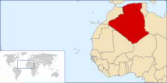
Geography of Algeria
 
|
|
| Continent | Africa |
|---|---|
| Region | North Africa |
| Coordinates | 28°00′N 3°00′E / 28.000°N 3.000°E |
| Area | Ranked 10th |
| • Total | 2,381,740 km2 (919,590 sq mi) |
| • Land | 100% |
| • Water | 0% |
| Coastline | 1,644 km (1,022 mi) |
| Borders |
Land boundaries: 6,343 km |
| Maritime claims | 32–52 nm |
| Highest point | Mount Tahat, 3,003 m |
| Lowest point | Chott Melrhir, −40 m |
| Longest river | Chelif River, 230 km |
| Climate | arid to semiarid |
| Terrain | mostly high plateau and desert, mountains, narrow coastal plain |
| Natural Resources | petroleum, natural gas, iron ore, phosphates, uranium, lead, zinc |
| Natural Hazards | earthquakes, mudslides, floods |
| Environmental Issues | soil erosion, desertification, pollution |
| Land Use | (2012 est.) |
|---|---|
| • Arable land | 3.17% |
| • Permanent crops | 0.29% |
| • Other | 96.45% |
| Irrigated Land | 5,694 km2 (2,198 sq mi) |
Land boundaries: 6,343 km
Morocco 1,559 km,
Mali 1,376 km,
Libya 982 km,
Tunisia 965 km,
Niger 956 km,
Mauritania 463 km,
Western Sahara 42 km
Algeria comprises 2,381,741 square kilometers of land, more than four-fifths of which is desert, in northern Africa, between Morocco and Tunisia. It is the largest country in Africa. Its Arabic name, Al Jazair (the islands), derives from the name of the capital Algiers (Al Jazair in Arabic), after the small islands formerly found in its harbor. It has a long Mediterranean coastline, most of which is more properly termed the Alboran Sea, which is the westernmost element of the Mediterranean Sea. The northern portion, an area of mountains, valleys, and plateaus between the Mediterranean Sea and the Sahara Desert, forms an integral part of the section of North Africa known as the Maghreb. This area includes Morocco, Tunisia, and the northwestern portion of Libya known historically as Tripolitania.
Land boundaries:
Total: 6,764 km (4,203 mi)
Border countries: Libya 989 km (615 mi), Mali 1,359 km (844 mi), Mauritania 460 km (290 mi), Morocco 1,559 km (969 mi), Niger 951 km (591 mi), Tunisia 1,034 km (642 mi), Western Sahara 41 km (25 mi).
Area – comparative: roughly 3.5 times the size of Texas and twice the size of Ontario.
Coastline: 1,620 km (1,010 mi)
Maritime claims:
Exclusive fishing zone: 32–52 nmi (59.3–96.3 km)
Territorial sea: 12 nmi (22.2 km)
...
Wikipedia
