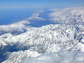
Caucasian mountain range
| Caucasus Mountains | |
|---|---|

Aerial view of the Caucasus Mountains
|
|
| Highest point | |
| Peak | Mount Elbrus |
| Elevation | 5,642 m (18,510 ft) |
| Coordinates | 43°21′18″N 42°26′31″E / 43.35500°N 42.44194°E |
| Dimensions | |
| Length | 1,100 km (680 mi) |
| Width | 160 km (99 mi) |
| Geography | |
| Countries | Russia, Georgia, Armenia and Azerbaijan |
| Range coordinates | 42°30′N 45°00′E / 42.5°N 45°ECoordinates: 42°30′N 45°00′E / 42.5°N 45°E |
The Caucasus Mountains are a mountain system in West Asia between the Black Sea and the Caspian Sea in the Caucasus region.
The Caucasus Mountains include the Greater Caucasus in the north and Lesser Caucasus in the south. The Greater Caucasus runs west-northwest to east-southeast, from the Caucasian Natural Reserve in the vicinity of Sochi on the northeastern shore of the Black Sea nearly to Baku on the Caspian Sea. The Lesser Caucasus runs parallel to the Greater about 100 km (62 mi) south. The Greater and Lesser Caucasus ranges are connected by the Likhi Range, and to the west and east of the Likhi Range lie the Colchis Plain and the Kur-Araz Lowland. The Meskheti Range is a part of the Lesser Caucasus system. In the southeast the Aras River separates the Lesser Caucasus from the Talysh Mountains which straddle the border of southeastern Azerbaijan and Iran. The Lesser Caucasus and the Armenian Highland constitute the Transcaucasian Highland, which at their western end converge with the highland plateau of Eastern Anatolia in the far north east of Turkey. The highest peak in the Caucasus range is Mount Elbrus in the Greater Caucasus, which rises to a height of 5,642 metres (18,510 ft) above sea level. Mountains near Sochi hosted part of the 2014 Winter Olympics.
...
Wikipedia

