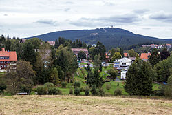
Braunlage
| Braunlage | ||
|---|---|---|

Braunlage and Wurmberg
|
||
|
||
| Coordinates: 51°43′37″N 10°36′43″E / 51.72694°N 10.61194°ECoordinates: 51°43′37″N 10°36′43″E / 51.72694°N 10.61194°E | ||
| Country | Germany | |
| State | Lower Saxony | |
| District | Goslar | |
| Government | ||
| • Mayor | Stefan Grote (SPD) | |
| Area | ||
| • Total | 31.55 km2 (12.18 sq mi) | |
| Elevation | 560 m (1,840 ft) | |
| Population (2015-12-31) | ||
| • Total | 6,803 | |
| • Density | 220/km2 (560/sq mi) | |
| Time zone | CET/CEST (UTC+1/+2) | |
| Postal codes | 38700 | |
| Dialling codes | 05520 | |
| Vehicle registration | GS, BRL, CLZ | |
| Website | www |
|
Braunlage is a town and health resort in the Goslar district in Lower Saxony in Germany. Situated within the Harz mountain range, south of the Brocken massif, Braunlage's main business is tourism, particularly skiing. Nearby ski resorts include the Sonnenberg and the slopes on the Wurmberg.
Braunlage is located on the Warme Bode, a headstream of the Bode river, close to the border with Elend in the state of Saxony-Anhalt. The municipal area stretches along the southeastern rim of the Harz National Park from an elevation of 550 m (1,800 ft) up to 971 m (3,186 ft) at the Wurmberg summit. Other peaks in the vicinity include the Achtermannshöhe and the Hahnenklee Crags.
The town consists of three districts:
Braunlage is situated at the Bundesstraßen B4 running from Braunschweig to Nordhausen and B27 from Blankenburg to Göttingen.
Local buses provide service between Braunlage and the nearby communities of Bad Harzburg, Sankt Andreasberg, Schierke, Wernigerode, Hohegeiß, Bad Sachsa, Nordhausen, Bad Lauterberg, Herzberg, and Clausthal-Zellerfeld.
...
Wikipedia


