Wernigerode
| Wernigerode | ||
|---|---|---|

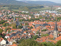
View over Wernigerode
|
||
|
||
| Coordinates: 51°50′6″N 10°47′7″E / 51.83500°N 10.78528°ECoordinates: 51°50′6″N 10°47′7″E / 51.83500°N 10.78528°E | ||
| Country | Germany | |
| State | Saxony-Anhalt | |
| District | Harz | |
| Government | ||
| • Mayor | Peter Gaffert (Ind.) | |
| Area | ||
| • Total | 170.03 km2 (65.65 sq mi) | |
| Population (2015-12-31) | ||
| • Total | 33,108 | |
| • Density | 190/km2 (500/sq mi) | |
| Time zone | CET/CEST (UTC+1/+2) | |
| Postal codes | 38855, 38879 | |
| Dialling codes | 03943, 039455 | |
| Vehicle registration | HZ, HBS, QLB, WR | |
| Website | www.wernigerode.de | |
Wernigerode (German pronunciation: [ˌvɛɐ̯nɪɡəˈʁoːdə]) is a town in the district of Harz, Saxony-Anhalt, Germany. Until 2007, it was the capital of the district of Wernigerode. Its population was 35,041 in 2012.
Wernigerode is located southwest of Halberstadt, and is picturesquely situated on the Holtemme river, on the north slopes of the Harz Mountains. Wernigerode is located on the German Timber-Frame Road.
The town lies at about 250 metres above sea level (NN) on the northeastern flank of the Harz Mountains in central Germany, at the foot of their highest peak, the Brocken, on the B 6 and B 244 federal highways and on the railway line from Halberstadt to Vienenburg that links the cities of Halle (Saale) and Hanover.
The River Holtemme flows through the town and, not far from its western gate, it is joined by the Zillierbach stream, which is also known as the Flutrenne near its mouth. North of the town the Barrenbach flows through several ponds and empties into the Holtemme in the village of Minsleben. The historic town centre consists of an old town and a new town (Altstadt and Neustadt). The town's borough includes Hasserode, Nöschenrode, the residential estates of Stadtfeld, Burgbreite and Harzblick as well as the villages of Benzingerode, Minsleben, Silstedt, Schierke and Reddeber.
...
Wikipedia


