Schierke
| Schierke | ||
|---|---|---|
| Stadtteil of Wernigerode | ||

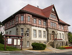
Town hall
|
||
|
||
| Coordinates: 51°45′50″N 10°39′53″E / 51.76389°N 10.66472°ECoordinates: 51°45′50″N 10°39′53″E / 51.76389°N 10.66472°E | ||
| Country | Germany | |
| State | Saxony-Anhalt | |
| District | Harz | |
| Town | Wernigerode | |
| Area | ||
| • Total | 40.13 km2 (15.49 sq mi) | |
| Population (2006-12-31) | ||
| • Total | 721 | |
| • Density | 18/km2 (47/sq mi) | |
| Time zone | CET/CEST (UTC+1/+2) | |
| Postal codes | 38879 | |
| Dialling codes | 039455 | |
| Vehicle registration | HZ | |
| Website | www.schierke-am-brocken.de | |
Schierke is a village and a former municipality in the Harz district, in the German state of Saxony-Anhalt. Since 1 July 2009, it is part of the town Wernigerode.
Schierke was first mentioned as Schiriken in a 1590 deed. Situated within the Harz mountain range in the valley of the Bode River, at the rim of the Harz National Park, it is mainly a tourist resort, especially for hiking and all kinds of winter sport. Since 1898 Schierke station has been served by the Harz Narrow Gauge Railways. In 1914 and 1934 it was the site of the German Skeleton Championships. Nevertheless, due to its location next to the former inner German border, visits to Schierke required an extra permission by East German authorities between 1952 and 1989.
Today Schierke again is a popular place to start or finish a walk to the Brocken mountain via the Goetheweg or the Glashüttenweg. It has bus service and access to the Brocken Railway, whose station is located about 100 metres above the village. A popular attraction in the area is the "Brocken Coaster", a local summer rodelbahn. Schierke is also not far from downhill skiing destinations such as the slope of the Wurmberg mountain, the second highest of the Harz. Another winter activity in the area involves hiring or obtaining a sled and riding it down the "bob bahn" – a local tobogganing track.
...
Wikipedia


