Bad Harzburg
| Bad Harzburg | ||
|---|---|---|

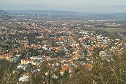
View from the Burgberg
|
||
|
||
| Coordinates: 51°52′52″N 10°33′44″E / 51.88111°N 10.56222°ECoordinates: 51°52′52″N 10°33′44″E / 51.88111°N 10.56222°E | ||
| Country | Germany | |
| State | Lower Saxony | |
| District | Goslar | |
| Government | ||
| • Mayor | Ralf Abrahms (Greens) | |
| Area | ||
| • Total | 65.42 km2 (25.26 sq mi) | |
| Elevation | 261 m (856 ft) | |
| Population (2015-12-31) | ||
| • Total | 21,735 | |
| • Density | 330/km2 (860/sq mi) | |
| Time zone | CET/CEST (UTC+1/+2) | |
| Postal codes | 38667 | |
| Dialling codes | 05322 | |
| Vehicle registration | GS | |
| Website | www.stadt-bad-harzburg.de | |
Bad Harzburg is a town in central Germany, in the Goslar district of Lower Saxony. It lies on the northern edge of the Harz mountains and is a recognised saltwater spa and climatic health resort.
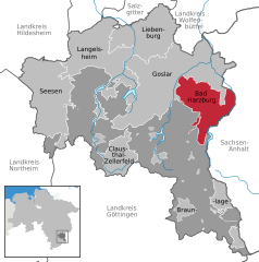
Bad Harzburg is situated at the northern foot of the Harz mountain range on the edge of the Harz National Park. To the east of the borough is the boundary between the states of Lower Saxony and Saxony-Anhalt, the former Inner German Border. The small Radau river, a tributary to the Oker, has its source in the Harz mountains and flows through the town. Nearby are the towns of Goslar to the west, Vienenburg to the north, Braunlage to the south and Ilsenburg and Osterwieck in the east.
The districts within the borough of Bad Harzburg, with their population in brackets, are:
Population: as at 31 December 2008
Climatically Bad Harzburg is a transition zone to a pure alpine region with a pronounced local climate.
According to legend, about 780 AD the Emperor Charlemagne, after the conquest of the area in the course of the Saxon Wars, had a chapel built on the Burgberg a hill overlooking the town. It may have stood on the site of a sacred grove dedicated to a Saxon god named Krodo, whose statue Charlemagne had overthrown.
...
Wikipedia


