Osterwieck
| Osterwieck | ||
|---|---|---|
|
||
| Coordinates: 51°58′N 10°43′E / 51.967°N 10.717°ECoordinates: 51°58′N 10°43′E / 51.967°N 10.717°E | ||
| Country | Germany | |
| State | Saxony-Anhalt | |
| District | Harz | |
| Government | ||
| • Mayor | Ulrich Simons (CDU) | |
| Area | ||
| • Total | 212.67 km2 (82.11 sq mi) | |
| Elevation | 123 m (404 ft) | |
| Population (2015-12-31) | ||
| • Total | 11,292 | |
| • Density | 53/km2 (140/sq mi) | |
| Time zone | CET/CEST (UTC+1/+2) | |
| Postal codes | 38835 | |
| Dialling codes | 039421, 039422, 039458 | |
| Vehicle registration | HZ | |
| Website | www.osterwieck.de | |
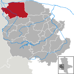
Osterwieck is a historic town in the Harz district, in the German state of Saxony-Anhalt. It is situated on the river Ilse, north of Wernigerode and the Harz mountain range. On 1 January 2010 the municipalities of the former Verwaltungsgemeinschaft Osterwieck-Fallstein merged in Osterwieck.
The Altstadt (Old Town) with St. Stephen's Church is a stop on the scenic German Timber-Frame Road and on the Romanesque Road.
The settlement was first mentioned about 780 when Charlemagne in course of the Saxon Wars crossed the Oker river and had a church dedicated to Saint Stephen erected at a place then called Salingenstede. This church became a centre of the Christian mission among the pagan Saxons, overseen by Hildegrim of Châlons, and the origin of the later Bishopric of Halberstadt. On April 1, 974 Emperor Otto II granted market and mint rights to Seligenstadt, it is commonly regarded as the date of the town's foundation.
The name Osterwieck was first mentioned in a 1073 letter by Archbishop Liemar of Bremen to Bishop Burchard II of Halberstadt. Destroyed by a blaze in 1511 the town was rebuilt and today features an ensemble of about 400 Fachwerk buildings. The nave of the St. Stephen Church erected in the 16th century is one of the oldest Protestant church buildings, while its Romanesque twin steeples date back to 1100.
...
Wikipedia


