Oker
| Oker | |
|---|---|

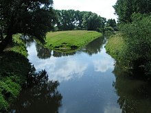
Confluence of the Oker and Aller near Müden
|
|
| Country | Germany |
| Basin features | |
| Main source |
Harz Mountains 900 metres (3,000 ft) 51°46′42″N 10°29′29″E / 51.77833°N 10.49139°E |
| River mouth |
Aller 52°31′26″N 10°21′39″E / 52.52389°N 10.36083°ECoordinates: 52°31′26″N 10°21′39″E / 52.52389°N 10.36083°E |
| Basin size | 1,800 km2 (690 sq mi) |
| Physical characteristics | |
| Length | 105 km (65 mi) |
The Oker is a river in Lower Saxony, Germany, that has historically formed an important political boundary. It is a left tributary of the River Aller, 105 kilometres (65 mi) in length and runs in a generally northerly direction.
The river's name was recorded around 830 as Obacra and, later, as Ovokare und Ovakara. The origin of the name is derived from the roots ov- and -akara meaning “upper” (cf. New High German ober-) and “onward rushing” (rendered in German as “Vorwärtsdrängende”) as distinct from its tributary, the Ecker, whose name means only “onward rushing”.
The Oker rises at about 910 metres in the Harz National Park in a boggy area on the Bruchberg in the Harz mountains of central Germany. This early section is known as the Große Oker ("Great Oker") and it is impounded below Altenau by the Oker Dam (Okertalsperre). From the dam wall to the former village of Oker, which is today part of the borough of Goslar, the Oker is on certain occasions suitable for canoeing. This section, often called the "Oker Valley" (Okertal), includes the Romkerhall Waterfall. Here the Romke stream drops about 64 metres in height over a waterfall laid out in 1863 into the Oker. Downstream in the river's fast-flowing waters, the Verlobungsinsel ("Betrothal Island") is to be found. Left and right of the Oker in this area are many crags that are popular with climbers.
In the Goslar vicinity of Oker the river is seriously polluted with heavy metals from the slag heaps as well as groundwater and surface runoff from the metal smelters there.
...
Wikipedia
