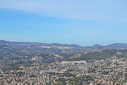
Benissa
| Benissa | |||
|---|---|---|---|
| Municipality | |||
 |
|||
|
|||
| Location in Spain | |||
| Coordinates: 38°42′54″N 0°03′00″E / 38.71500°N 0.05000°E | |||
| Country |
|
||
| Autonomous community |
|
||
| Province | Alicante | ||
| Comarca | Marina Alta | ||
| Judicial district | Dénia | ||
| Government | |||
| • Mayor | Abel Cardona (2017) (Reiniciem Benissa) | ||
| Area | |||
| • Total | 69.71 km2 (26.92 sq mi) | ||
| Elevation | 254 m (833 ft) | ||
| Population (2009) | |||
| • Total | 13,221 | ||
| • Density | 190/km2 (490/sq mi) | ||
| Demonym(s) | Benissenc, benissenca | ||
| Time zone | CET (UTC+1) | ||
| • Summer (DST) | CEST (UTC+2) | ||
| Postal code | 03720 | ||
| Official language(s) | Valencian | ||
| Website | Official website | ||
Coordinates: 38°42′52.2″N 0°3′9.8″E / 38.714500°N 0.052722°E
Benissa (Valencian pronunciation: [beˈnisa], Spanish: Benisa) is a small town in Spain in the province of Alicante, 275 m above sea level, and one of the oldest towns on the Costa Blanca.
The municipality of Benissa has 4 km of coastline linking the towns of Moraira and Calp. The scenery of the area includes cliff tops, rocky coves, sandy beaches and tiny bays along the Benissa Costa. The territory of Benissa also contains terraced vineyards, mountains and palm trees. Spanish village houses, with doorsteps directly onto the street, internal courtyards and deceptively spacious inside. Old finques (a farm or country estate) sit on large plots amongst vineyards with panoramic views to the sea.
Nearby towns along the Costa Blanca are La Fustera, Cala dels Pinets, Cala de La Llobella, Cala l'Advocat, Baladrar and Cap Blanc before reaching Moraira.
The toponym of Benissa comes from the Arabic tribal name Beni-Hisa or Beni-Eyce.(sons of Christ) After the Christian reconquest (1248) by the troops of James II of Aragon, the town was settled by people from the Pyrenees, Catalonia and Aragon along with the former inhabitants, although the majority of the population remained Muslim for centuries. The last Muslim citizens were expelled in 1609.
...
Wikipedia


