Zhonghe, Taiwan
|
Zhonghe 中和區 |
|
|---|---|
| District | |
| Zhonghe District | |

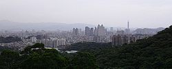
Zhonghe District, with Taipei 101 in the background
|
|
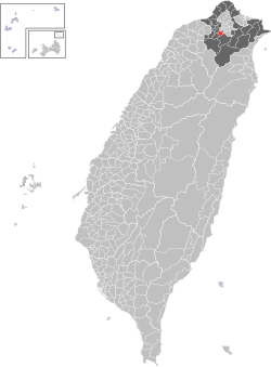
 Location of Zhonghe in New Taipei City |
|
| Coordinates: 24°59′50″N 121°30′15″E / 24.99722°N 121.50417°ECoordinates: 24°59′50″N 121°30′15″E / 24.99722°N 121.50417°E | |
| Country | Taiwan |
| Region | Northern Taiwan |
| Special municipality | New Taipei City (新北市) |
| Area | |
| • Total | 20.294 km2 (7.836 sq mi) |
| Population (January 2016) | |
| • Total | 414,356 |
| Time zone | CST (UTC+8) |
| Postal code | 235 |
| Website | http://www.zhonghe.ntpc.gov.tw |
| Zhonghe District | |||||||||||||||||||||||||||
| Chinese | 中和區 | ||||||||||||||||||||||||||
|---|---|---|---|---|---|---|---|---|---|---|---|---|---|---|---|---|---|---|---|---|---|---|---|---|---|---|---|
|
|||||||||||||||||||||||||||
| Transcriptions | |
|---|---|
| Standard Mandarin | |
| Hanyu Pinyin | Zhōnghé Qū |
| Bopomofo | ㄓㄨㄥ ㄏㄜˊ ㄑㄩ |
| Gwoyeu Romatzyh | Jongher Chiu |
| Tongyong Pinyin | Jhonghé Cyu |
| MPS2 | Jūnghé Chiu |
| Hakka | |
| Romanization | Zung1-fo2 Sii5 |
| Yue: Cantonese | |
| Jyutping | zong1 wo4 si5 |
| Southern Min | |
| Hokkien POJ | Tiong-hô Khu |
Zhonghe District (Chinese: 中和區; Hanyu Pinyin: Zhōnghé Qū; Tongyong Pinyin: Jhonghé Cyu, Pe̍h-ōe-jī: Tiong-hô Khu), historically spelled Chung-Ho and Jhonghe, is an inner city district in New Taipei in northern Taiwan (Republic of China). Zhonghe is a burgeoning satellite city of Taipei.
Zhonghe lies just south-west of Taipei City and shares borders with Banqiao, Xindian, Tucheng and Yonghe Districts of New Taipei City, as well as Taipei City. The average annual temperature is 21.7 °C (71.1 °F) and the precipitation averages 2,111 millimetres (83.1 in) per year. Most of Zhonghe lies a few tens of meters above sea level and is heavily urbanized, with forested hillier country in the southeast. A mountainous ridge forms most of the eastern border with Xindian, which includes the highest point in Zhonghe, the 302-meter Fenglusai (Chinese: 風爐塞山; pinyin: Fēnglúsài Shān).
The present-day area of Zhonghe District was originally settled by aboriginal tribes. During conflict between the colonial forces of the Dutch and the Spanish, the area is recorded by the Dutch as Chiron, from the name of one of the tribes living there. This name is preserved in one of the constituent villages of the city, called Xiulang Li (秀朗里), and the bridge which connects Zhonghe to Xindian.
The area was subsequently settled by Han Chinese migrants from Fujian but remained relatively unimportant until the end of the Second World War. In 1946 the population of the area of present-day Zhonghe and Yonghe was 30,000 and it was classified as a rural township.
...
Wikipedia
