Yellow sea
| Yellow Sea | |||||||||||||||
 |
|||||||||||||||
| Chinese name | |||||||||||||||
|---|---|---|---|---|---|---|---|---|---|---|---|---|---|---|---|
| Simplified Chinese | |||||||||||||||
| Traditional Chinese | |||||||||||||||
| Literal meaning | yellow sea | ||||||||||||||
|
|||||||||||||||
| Korean name | |||||||||||||||
| Hangul | or | ||||||||||||||
| Hanja | or | ||||||||||||||
| Literal meaning | yellow sea or west sea | ||||||||||||||
|
|||||||||||||||
| Transcriptions | |
|---|---|
| Standard Mandarin | |
| Hanyu Pinyin | huáng hǎi |
| Wu | |
| Romanization | waon入 hae平 |
| Yue: Cantonese | |
| Jyutping | wong4 hoi2 |
| Transcriptions | |
|---|---|
| Revised Romanization | Hwanghae or Seohae |
| McCune–Reischauer | Hwanghae or Sŏhae |
| Yellow Sea | |
|---|---|
| Coordinates | 35°0′N 123°0′E / 35.000°N 123.000°ECoordinates: 35°0′N 123°0′E / 35.000°N 123.000°E |
| River sources | Yellow River, Hai River, Yalu River, Taedong River, Han River |
| Basin countries |
China North Korea South Korea |
| Surface area | 380,000 km2 (150,000 sq mi) |
| Average depth | Avg. 44 m (144 ft) |
| Max. depth | Max. 152 m (499 ft) |
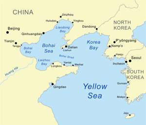
The Yellow Sea is the name given to the northern part of the East China Sea, which is a marginal sea of the Pacific Ocean. It is located between mainland China and the Korean Peninsula. Its name comes from the sand particles from Gobi Desert sand storms that turn the surface of the water golden yellow.
The innermost bay of the Yellow Sea is called the Bohai Sea (previously Pechihli Bay or Chihli Bay). Into it flow both the Yellow River (through Shandong province and its capital Jinan) and Hai He (through Beijing and Tianjin). Deposits of sand and silt from those rivers contribute to the sea colour.
The northern extension of the Yellow Sea is called the Korea Bay.
The Yellow Sea is one of four seas named after common colour terms — the others being the Black Sea, the Red Sea and the White Sea.
The International Hydrographic Organization defines the limits of the Yellow Sea (which it also names as "Hwang Hai") as follows:
On the South. The parallel of 33°17' North from Saisyu To (Quelpart) [now known as Jeju-do] to the mainland [of China]. On the Southeast. From the Western extreme of Quelpart to Ka Nyo or West Pinnacle Island (34°13'N) in the Mengoru Group, thence to the North point of Oku To (34°22'N), to the West point of Small South Stone Island (Syo-Zyonan To) and the North point of Great South Stone Island (Zyonan To) (34°24'N) to a point on the coast of Tin To (34°25'N) along the Northwest coast of this island to the North point thereof, and thence on a line in a Northeasterly direction to the mainland of Tyosen (Korea).
...
Wikipedia
