Han River (Korea)
| Han (한강) | |
| River | |
|
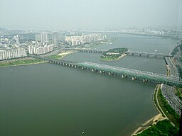
Hangang Railway Bridge crossing the Han.
|
|
|
Name origin: Baekje Hanja, "Hansu" (漢水) |
|
| Countries | South Korea (KOR), North Korea (PRK) |
|---|---|
| Provinces | Gangwon (KOR), Gyeonggi (KOR), Seoul (KOR), North Hwanghae (PRK) |
| Parts | Goljicheon, Joyang River, Dong River, Namhan River |
| Tributaries | |
| - left | Dalcheon, Cheongmicheon, Bokhacheon, Gyeongancheon, Anyangcheon, Ara Canal † |
| - right | Seom River, Bukhan River, Jungnangcheon, Gongneungcheon, Rimjin River |
| Source | Taebaek Mountains |
| - location | Geumdae Peak, Taebaek, Gangwon, South Korea |
| Mouth | Yellow Sea |
| - location | Northwestern tip of Gimpo peninsula, KOR-PRK border |
| Length | 494 km (307 mi) |
| Basin | 35,770 km2 (13,811 sq mi) |
| Discharge | for Hangang Bridge, Seoul |
| - average | 613 m3/s (21,648 cu ft/s) |
| † : Distributary of Han | |
| Han river | |
| Hangul | |
|---|---|
| Hanja | |
| Revised Romanization | Han(-)gang |
| McCune–Reischauer | Han'gang |
The Han River or Hangang (Korean pronunciation: [ha(ː)n.ɡaŋ]) is a major river in South Korea and the fourth longest river on the Korean peninsula after the Amnok (Yalu), Tuman (Tumen), and Nakdong rivers. The river begins as two smaller rivers in the eastern mountains of the Korean peninsula, which then converge near Seoul, the capital of the country.
The Han River and its surrounding area have played an important role in Korean history. The Three Kingdoms of Korea strove to take control of this land, where the river was used as a trade route to China (via the Yellow Sea). However, the river is no longer actively used for navigation, because its estuary is located at the borders of the two Koreas, barred for entrance by any civilian.
The river serves as a water source for over 12 million Koreans. In July 2000, the US military admitted to having dumped toxic chemicals in the river; causing protests.
Currently, the lower stretches of the Han river are lined with pedestrian walkways, bicycle paths, public parks and restaurants, particularly in Seoul. In a 2011 survey conducted by Seoul Development Institute of 800 residents and 103 urban planning and architectural experts, 51.3 percent of residents and 68.9 percent of experts voted the river the second most scenic location in the city, following Mount Namsan in the top spot.
The Han is formed by the confluence of the Namhan River (South Han River), which originates in Mount Daedeok, and the Bukhan River (North Han River), which originates on the slopes of Kumgang Mountain in North Korea. The River flows through Seoul and then merges with the Rimjin River shortly before it flows into the Yellow Sea. The two major branches of the river, the Namhan River and the Bukhan River, come together at Yangpyeong, Gyeonggi province, at which point it is referred to as the Han River. It then passes through Seoul and continues on to the Yellow Sea. Broad tidal flats can be found at the mouth of the Han River, where it meets the sea along the Korean Demilitarized Zone that divides South and North Korea.
...
Wikipedia


