Wisconsin Highway 20
| State Trunk Highway 20 | ||||
|---|---|---|---|---|
 |
||||
| Route information | ||||
| Maintained by WisDOT | ||||
| Length: | 42.95 mi (69.12 km) | |||
| Major junctions | ||||
| West end: |
|
|||
|
|
||||
| East end: |
|
|||
| Location | ||||
| Counties: | Walworth, Racine | |||
| Highway system | ||||
|
||||
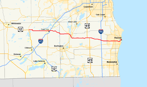
State Trunk Highway 20 (often called Highway 20, STH 20 or WIS 20) is a state highway in the U.S. state of Wisconsin. The route is a short connector that bridges the city of Whitewater and points west (via U.S. Route 12) with East Troy, Waterford and Racine. WIS 20 is a two-lane surface road with various four-lane roads within cities.
WIS 20 begins at the junction of US 12 and WIS 67 and proceeds east, going south around a junction with CTH J one and one-half miles east of the terminus and bypassing the small community of Troy Center. WIS 20 connects with I-43 in East Troy, then meanders eastward into Racine County WIS 20 provides indirect access to Alpine Valley Music Theater which is south of the village just off WIS 120 WIS 20 merges with WIS 83 east on the west side of Waterford and both highways turn southeast into the village. WIS 83 splits to the south at WIS 20's junction with WIS 36 in Rochester. From here, WIS 20 turns east again, where it becomes Washington Avenue. WIS 20 connects with WIS 75 and crosses US 45 in the town of Yorkville.
...
Wikipedia

