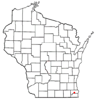
Union Grove, Wisconsin
| Union Grove, Wisconsin | |
|---|---|
| Village | |
 Location of Union Grove, Wisconsin |
|
| Coordinates: 42°41′7″N 88°2′58″W / 42.68528°N 88.04944°WCoordinates: 42°41′7″N 88°2′58″W / 42.68528°N 88.04944°W | |
| Country | United States |
| State | Wisconsin |
| County | Racine |
| Area | |
| • Total | 2.47 sq mi (6.40 km2) |
| • Land | 2.47 sq mi (6.40 km2) |
| • Water | 0 sq mi (0 km2) |
| Elevation | 774 ft (236 m) |
| Population (2010) | |
| • Total | 4,915 |
| • Estimate (2012) | 4,884 |
| • Density | 1,989.9/sq mi (768.3/km2) |
| Time zone | Central (CST) (UTC-6) |
| • Summer (DST) | CDT (UTC-5) |
| Area code(s) | 262 |
| FIPS code | 55-81775 |
| GNIS feature ID | 1575902 |
Union Grove is a village in Racine County, Wisconsin, United States. The population was 4,322 at the 2000 census and 4,915 at the 2010 census.
Governor Henry Dodge named the area that became Union Grove, combining the word “Union” with “Grove” because of the gorgeous grove of burr oak trees on the west side of the land.
Union Grove is located at 42°41′7″N 88°2′58″W / 42.68528°N 88.04944°W (42.685287, -88.049390).
According to the United States Census Bureau, the village has a total area of 2.47 square miles (6.40 km2), all of it land.
As of the census of 2010, there were 4,915 people, 1,881 households, and 1,269 families residing in the village. The population density was 1,989.9 inhabitants per square mile (768.3/km2). There were 1,960 housing units at an average density of 793.5 per square mile (306.4/km2). The racial makeup of the village was 96.6% White, 0.5% African American, 0.3% Native American, 0.6% Asian, 0.5% from other races, and 1.5% from two or more races. Hispanic or Latino of any race were 3.2% of the population.
...
Wikipedia
