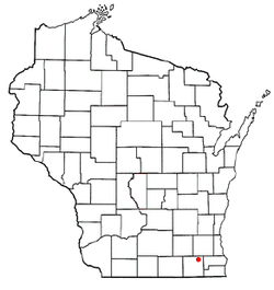
East Troy, Wisconsin
| East Troy, Wisconsin | |
|---|---|
| Village | |
 Location of East Troy, Wisconsin |
|
| Coordinates: 42°48′N 88°24′W / 42.800°N 88.400°WCoordinates: 42°48′N 88°24′W / 42.800°N 88.400°W | |
| Country | United States |
| State | Wisconsin |
| County | Walworth |
| Area | |
| • Total | 4.51 sq mi (11.68 km2) |
| • Land | 4.47 sq mi (11.58 km2) |
| • Water | 0.04 sq mi (0.10 km2) |
| Elevation | 833 ft (254 m) |
| Population (2010) | |
| • Total | 4,281 |
| • Estimate (2012) | 4,310 |
| • Density | 957.7/sq mi (369.8/km2) |
| Time zone | Central (CST) (UTC-6) |
| • Summer (DST) | CDT (UTC-5) |
| Area code(s) | 262 |
| FIPS code | 55-22125 |
| GNIS feature ID | 1583120 |
East Troy is a village in Walworth County, Wisconsin, United States. The population was 4,281 at the 2010 census. The village is located southeast of the Town of East Troy. A small portion extends into the adjacent Town of Troy. The village is surrounded by lakes, Booth Lake and Lake Beulah being the biggest and most popular.
East Troy is located at 42°48′N 88°24′W / 42.800°N 88.400°W (42.7868, -88.4036).
According to the United States Census Bureau, the village has a total area of 4.51 square miles (11.68 km2), of which, 4.47 square miles (11.58 km2) of it is land and 0.04 square miles (0.10 km2) is water.
East Troy is serviced by the East Troy Municipal Airport, (FAA LID: 57C).
As of the census of 2010, there were 4,281 people, 1,737 households, and 1,125 families residing in the village. The population density was 957.7 inhabitants per square mile (369.8/km2). There were 1,866 housing units at an average density of 417.4 per square mile (161.2/km2). The racial makeup of the village was 95.9% White, 0.4% African American, 0.5% Native American, 0.6% Asian, 0.1% Pacific Islander, 1.1% from other races, and 1.4% from two or more races. Hispanic or Latino of any race were 4.0% of the population.
...
Wikipedia
