West Boylston
| West Boylston, Massachusetts | ||
|---|---|---|
| Town | ||

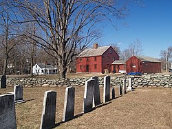
Bigelow Tavern (Historical Society)
|
||
|
||
| Motto: "Small Town, Big Heart" | ||
 Location in Worcester County and the state of Massachusetts. |
||
| Coordinates: 42°22′00″N 71°47′10″W / 42.36667°N 71.78611°WCoordinates: 42°22′00″N 71°47′10″W / 42.36667°N 71.78611°W | ||
| Country | United States | |
| State | Massachusetts | |
| County | Worcester | |
| Settled | 1642 | |
| Incorporated | 1808 | |
| Government | ||
| • Type | Open town meeting | |
| • Town Administrator |
Leon Gaumond, Jr. | |
| • Board of Selectmen |
Kevin McCormick Christopher Rucho Allen Phillips Alexander Fallavollita John B. DiPietro, Sr. |
|
| Area | ||
| • Total | 13.8 sq mi (35.8 km2) | |
| • Land | 12.9 sq mi (33.4 km2) | |
| • Water | 1.0 sq mi (2.5 km2) | |
| Elevation | 481 ft (147 m) | |
| Population (2010) | ||
| • Total | 7,669 | |
| • Density | 560/sq mi (210/km2) | |
| Time zone | Eastern (UTC-5) | |
| • Summer (DST) | Eastern (UTC-4) | |
| ZIP code | 01583 | |
| Area code(s) | 508 / 774 | |
| FIPS code | 25-75155 | |
| GNIS feature ID | 0618391 | |
| Website | http://www.westboylston.com/Pages/index | |
West Boylston is a town in Worcester County, Massachusetts, United States. The population was 7,669 at the 2010 census. West Boylston includes the village of Oakdale, located on the opposite side of the Wachusett Reservoir from West Boylston center along Route 140.
West Boylston was originally part of several neighboring towns – Lancaster, Shrewsbury, Boylston, Holden and Sterling. The town was created as part of a dispute between Boylston and West Boylston over the location of a new town meeting house. It was incorporated in 1808.
During the 1800s the town grew with textile and other industries and became a prosperous community. This prosperity was interrupted as the town was selected as the site of the Wachusett Reservoir to provide water for Boston. It was selected due to its location at the junction of three rivers: the Quinapoxet River, the Stillwater River and the Nashua River. In 1897, the Nashua River in the town of Clinton was impounded by the Wachusett Dam. 6.5 square miles (17 km2) were flooded in the towns of Boylston, West Boylston, Clinton and Sterling. Over 2,200 acres (8.9 km2) of West Boylston's land was used for the reservoir, the most of any town. This disrupted the center of town and most of the industrial base. Many buildings were moved to the unaffected parts of the town but the majority were demolished and filled by the reservoir. Over 1700 residents, 300 homes, eight schools, six mills, four churches and one hotel were moved to dry land. The state paid approximately 60 cents on the dollar for use of the land with the promise to pay $12,000 a year to the town for lost tax revenue forever. The reservoir was completed in 1905 and first filled in May 1908. West Boylston's prominent landmark, the Old Stone Church, was left remaining as a reminder of those that lost their homes and jobs to the building of the reservoir. It is one of the most photographed sites in the area.
...
Wikipedia

