US 50
| U.S. Route 50 | |
|---|---|

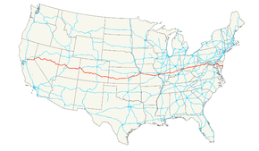
The Interstate Highway System with US 50 in red
|
|
| Route information | |
| Length: | 3,008 mi (4,841 km) |
| Existed: | 1926 – present |
| Major junctions | |
| West end: |
|
|
|
| East end: |
|
| Location | |
| States: | California, Nevada, Utah, Colorado, Kansas, Missouri, Illinois, Indiana, Ohio, West Virginia, Virginia, District of Columbia, Maryland |
| Highway system | |
U.S. Route 50 (US 50) is a major east–west route of the U.S. Highway system, stretching just over 3,000 miles (4,800 km) from West Sacramento, California, to Ocean City, Maryland, on the Atlantic Ocean. Until 1972, when it was replaced by Interstate Highways west of the Sacramento area, it extended (by way of , the Altamont Pass, and the Bay Bridge) to San Francisco, near the Pacific Ocean. The Interstates were constructed later and are mostly separate from this route. It generally serves a corridor south of Interstates 70 and 80 and north of Interstates 64 and 40. The route runs through mostly rural desert and mountains in the Western United States, with the section through Nevada known as "The Loneliest Road in America". In the Midwest, US 50 continues through mostly rural areas of farms as well as a few large cities including Kansas City, Missouri; St. Louis, Missouri; and Cincinnati, Ohio. The route continues into the Eastern United States, where it passes through the Appalachian Mountains in West Virginia before heading through Washington, D.C. From there, US 50 continues through Maryland as a high-speed road to Ocean City. Signs at each end give the length as 3,073 miles (4,946 km), but the actual distance is slightly less, due to realignments since the former figure was measured. US 50 passes through a total of 12 states; California, Nevada, Utah, Colorado, Kansas, Missouri, Illinois, Indiana, Ohio, West Virginia, Virginia, and Maryland, as well as the District of Columbia.
...
Wikipedia

