Altamont Pass
| Altamont Pass | |
|---|---|

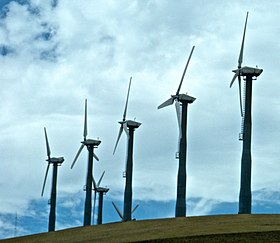
Wind turbines at Altamont Pass near Livermore, California
|
|
| Elevation | 741 ft (226 m) |
| Traversed by | Altamont Pass Road, Union Pacific Railroad |
| Location | Alameda County, California |
| Range | Diablo Range |
| Coordinates | 37°44′45″N 121°39′30″W / 37.74583°N 121.65833°WCoordinates: 37°44′45″N 121°39′30″W / 37.74583°N 121.65833°W |
| Topo map | Altamont |
| New Altamont Pass | |
|---|---|

View from westbound I-580 of Altamont Pass.
|
|
| Elevation | 1,009 ft (308 m) |
| Traversed by |
|
| Location | Alameda County, California |
| Range | Diablo Range |
| Coordinates | 37°43′9″N 121°39′33″W / 37.71917°N 121.65917°W |
| Topo map | Altamont |
Altamont Pass, formerly Livermore Pass, is a mountain pass in the Diablo Range of Northern California between Livermore in the Livermore Valley and Tracy in the San Joaquin Valley. The name is actually applied to two distinct but nearby crossings of the range. The lower of the two, at an elevation of 741 ft (226 m), carries two railroad rights-of-way (ROWs) and Altamont Pass Road, part of the old Lincoln Highway and the original alignment of US 50 before it was bypassed c. 1937. The bypass route travels over the higher summit, at 1,009 ft (308 m), and now carries Interstate 580, a major regional highway heavily congested by Central Valley suburbanization.
Of the two railroad lines through the old pass, one is still in use: the original Western Pacific line now owned by Union Pacific. It carries freight trains as well as the Altamont Commuter Express, which operates between , Livermore, Pleasanton, Fremont, and San Jose. The abandoned right-of-way was used by the Southern Pacific, now also part of Union Pacific. This line was the Bay Area's original connection to the transcontinental railroad, from 1869 until 1879, when a sea level ferry crossing at the Carquinez Strait replaced it. The route remained in use for other purposes, but it was abandoned in 1984 in favor of trackage rights on the ex-Western Pacific line.
...
Wikipedia
