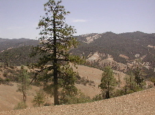
Diablo Range
| Diablo Range | |
|---|---|

The Diablo Range in the vicinity of San Benito Mountain
|
|
| Highest point | |
| Elevation | 1,597 m (5,240 ft) |
| Geography | |
|
Location of the Diablo Mountain Range in California, U.S.
|
|
| Country | United States |
| State | California |
| Region | Central California |
| Range coordinates | 36°22′11″N 120°38′39″W / 36.3697°N 120.6443°WCoordinates: 36°22′11″N 120°38′39″W / 36.3697°N 120.6443°W |
| Topo map | USGS San Benito Mountain |
The Diablo Range is a mountain range in the California Coast Ranges subdivision of the Pacific Coast Ranges. It is located in the eastern San Francisco Bay area south to the Salinas Valley area of northern California, the United States.
The Diablo Range extends from the Carquinez Strait in the north to Orchard Peak in the south, near the point where State Route 46 crosses over the Coast Ranges at Cholame, as described by the USGS. It is bordered on the northeast by the San Joaquin River, on the southeast by the San Joaquin Valley, on the southwest by the Salinas River, and on the northwest by the Santa Clara Valley. The USGS designation is somewhat ambiguous north of the Santa Clara Valley, but on their maps, the range is shown as the ridgeline which runs between its namesake Mount Diablo southeastward past Mount Hamilton. Geologically, the range corresponds to the California Coast Ranges east of the Calaveras Fault in this northern section.
For much of the length of the Diablo Range, it is paralleled by other sections of the California Coast Ranges to the west, the Santa Cruz Mountains across the southern San Francisco Bay and Santa Clara Valley, and the Santa Lucia Range across the Salinas Valley.
...
Wikipedia

