Salinas River (California)
| Salinas River | |
| Rio del Monterey, Rio San Antonio, Rio San Elizario, Rio Santa Delfina | |
| River | |
|
View of the Salinas River near San Ardo during the "rainy-season." During the rainier winter months, the river may occasionally reconnect with Monterey Bay. The San Ardo Oil Field is visible in the distance.
|
|
| Country | United States |
|---|---|
| State | California |
| Tributaries | |
| - left | Nacimiento River, San Antonio River, Arroyo Seco |
| - right | Estrella River, San Lorenzo Creek |
| Cities | Paso Robles, Soledad, Salinas |
| Source | Los Machos Hills in the Los Padres National Forest |
| - location | San Luis Obispo County, California |
| - elevation | 2,150 ft (655 m) |
| - coordinates | 35°12′57.2394″N 120°13′26.112″W / 35.215899833°N 120.22392000°W |
| Mouth | Monterey Bay |
| - location | 6 miles north of Marina, California |
| - elevation | 0 ft (0 m) |
| - coordinates | 36°44′58″N 121°48′13″W / 36.74944°N 121.80361°WCoordinates: 36°44′58″N 121°48′13″W / 36.74944°N 121.80361°W |
| Length | 175 mi (282 km) |
| Basin | 4,160 sq mi (10,774 km2) |
| Discharge | for near Spreckels |
| - average | 421 cu ft/s (12 m3/s) |
| - max | 95,000 cu ft/s (2,690 m3/s) |
| - min | 0 cu ft/s (0 m3/s) |
|
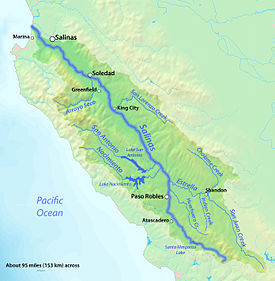
Map of the Salinas River watershed
|
|
The Salinas River is the longest river of the central coast of California, running 175 miles (282 km) and draining 4,160 square miles. It flows north-northwest and drains the Salinas Valley that slices through the central California Coast Ranges south of Monterey Bay. The river begins in southern San Luis Obispo county, originating in the Los Machos Hills of the Los Padres National Forest. From there, the river channel eventually makes its way to connect with the Pacific Ocean approximately 5 miles south of Moss Landing. The river is a wildlife corridor, and provides the principal source of water from its reservoirs and tributaries for the farms and vineyards of the valley.
Until only recently, the Salinas River had a continuous flow throughout the year, stretching back to at least 1941 (when USGS complete monitoring records in the Salinas area began,) and all of the way up through until 1989. Most probably due to recent increases in agricultural and consumer water demand in the Salinas Valley, and the resultant lowering of water tables, the lower reaches of the Salinas river (north of King City) have remained mostly dry since 2013; however, heavy rainfall can temporarily restart the flow of the river, as occurred in the beginning of 2017.
In 1769 when the river was first discovered by the Portola expedition, it was reported by them as being a "river watering a luxuriant plain" filled with fish weighing 8 or 10 pounds. As of 2016, it has been transformed into little more than a dry bedded run-off feature for the majority of its length.
Nonetheless, with sufficiently heavy rains, and on rare occasions, this now normally dry runoff feature is still capable of quickly transforming itself back into a fast flowing river. In rainfall induced flood conditions, it can at times measure over a mile in width. During the 20th century, such flood conditions are reported to have generally occurred approximately once every 3 to 10 years. The last similar flooding event along the river was reported in 1998.
The current typically dry or zero flow state of the majority of the river may be more the result of human activity than of any recent changes in weather patterns. Rainfall patterns of recent years in the Salinas area have not significantly changed from historical average rainfall patterns (139 year average annual rainfall in Salinas is 13.26 inches per year, average annual rainfall since 2000 is 11.01 inches per year). Recent increases in agricultural water use, individual consumer water use, and damming along the river may be contributing factors causing the now mostly dry condition of the riverbed.
...
Wikipedia


