Los Padres National Forest
| Los Padres National Forest | |
|---|---|
|
IUCN category VI (protected area with sustainable use of natural resources)
|
|

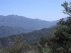
Jameson Reservoir is center. To the right are the Santa Ynez Mountains, to the left the Los Padres back country and Old Man Mountain. In the far distance is Reyes Peak.
|
|
| Location | California |
| Nearest city | Santa Barbara, Big Sur, and San Luis Obispo |
| Coordinates | 34°40′N 119°45′W / 34.667°N 119.750°WCoordinates: 34°40′N 119°45′W / 34.667°N 119.750°W |
| Area | 2,970 sq mi (7,700 km2) |
| Established | December, 1936 |
| Governing body | U.S. Forest Service |
| Website | Los Padres National Forest |
| China Camp | |
|---|---|
| Location | California, United States |
| Elevation | 4,260 ft (1,300 m) |
| Type | Drive In |
| Land | Los Padres National Forest |
| Campsites | 6 |
| Facilities | Vault Toilets, Picnic Tables |
| Water | No |
| Fee | None |
| Fires | Yes |
Los Padres National Forest is a United States national forest in southern and central California. Administered by the United States Forest Service, Los Padres includes most of the mountainous land along the California coast from Ventura to Monterey, extending inland. Elevations range from sea level to 8,847 feet (2,697 m).
The forest is approximately 1,950,000 acres (7,890 km2) in area, of which 1,762,400 acres (7,130 km2) or about 88% are public lands; the rest are privately owned inholdings.
The forest is divided between two noncontiguous areas. The northern division is within Monterey County and includes the beautiful Big Sur Coast and scenic interior areas. This is a very popular area for hiking, with 323 miles (520 km) of hiking trails and 11 campgrounds (ranging from very rugged to suitable for recreational vehicles). This division also contains the Ventana Wilderness, home to the California condor.
The "main division" of the forest includes lands within San Luis Obispo, Santa Barbara, Ventura and Kern Counties, with a small extension into Los Angeles County in the Pyramid Lake area, between Castaic and Gorman. Mountain ranges within the Los Padres include the Santa Lucia Mountains, La Panza Range, Caliente Range (a small part), Sierra Madre Mountains, San Rafael Mountains, Santa Ynez Mountains, and Topatopa Mountains; the highest parts of the forest are not within named mountain ranges, but are adjacent to the western San Emigdio Mountains and include Mount Pinos, Cerro Noroeste, and Reyes Peak. The forest is also adjacent to the Angeles National Forest, which is in Los Angeles County in Southern California and is nearby Carrizo Plain National Monument in eastern San Luis Obispo County. Forest headquarters are located in Goleta, California. There are local ranger district offices in Frazier Park, King City, Ojai, Santa Barbara, and Santa Maria.
...
Wikipedia
