San Rafael Mountains
| San Rafael Mountains | |
|---|---|

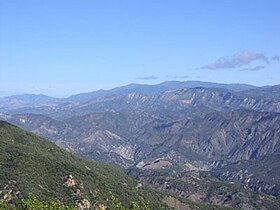
San Rafael Mountains from near La Cumbre Peak with McKinley Mountain and San Rafael Mountain visible in the distance
|
|
| Highest point | |
| Peak | Big Pine Mountain |
| Elevation | 6,820 ft (2,080 m) |
| Coordinates | 34°41′50″N 119°39′16″W / 34.69722°N 119.65444°W |
| Geography | |
|
location of San Rafael Mountains in California
|
|
| Country | United States |
| State | California |
| District | Santa Barbara County |
| Range coordinates | 34°42′39″N 119°48′51″W / 34.7108°N 119.8143°WCoordinates: 34°42′39″N 119°48′51″W / 34.7108°N 119.8143°W |
| Parent range | Transverse Ranges system |
| Topo map | USGS San Rafael Mountain |
| Biome | California chaparral and woodlands |
The San Rafael Mountains are a mountain range in central Santa Barbara County, California, U.S., separating the drainages of the Santa Ynez River and the Santa Maria River. They are part of the Transverse Ranges system of Southern California which in turn are part of the Pacific Coast Ranges system of western North America.
Most of the mountain range is within the Los Padres National Forest, and the northern slopes are included in the remote San Rafael Wilderness area.
The highest peaks include Big Pine Mountain (6,820 ft, 2,079 m), San Rafael Mountain (6,593 ft, 2,010 m) and McKinley Mountain (6,220 ft, 1,896 m), none of which are easily accessible except by foot or horse. The highest peak at the southern edge of the range is Little Pine Mountain.
Hurricane Deck is a spectacular block of sandstone that can be found deep in the San Rafael Wilderness.
The Sisquoc River headwaters are on the north slopes of Big Pine Mountain. It is a designated Wild and Scenic River of the United States, and a tributary of the Santa Maria River. Sisquoc Falls, 250 feet (76 m) high, is located on a tributary of the Sisquoc RIver to the west of Big Pine Mountain.
Climate is moderate, with hot dry summers (rare thunderstorms) and cool to cold wet winters. Snow sometimes falls on the higher slopes between December and March during frontal passages. Annual precipitation totals are between 15 and 25 inches.
...
Wikipedia

