Santa Ynez River
| Santa Ynez River | |
| Río Grande de San Vernardo | |
| River | |
|
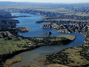
Lake Cachuma, a reservoir on the Santa Ynez River. The river is visible at the far bottom of the image.
|
|
| Country | United States |
|---|---|
| State | California |
| County | Santa Barbara |
| Tributaries | |
| - left | Alder Creek, Alisal Creek, Salsipuedes Creek, Miguelito Creek |
| - right | Santa Cruz Creek, Cachuma Creek, Santa Agueda Creek, Zanja de Cota Creek, Alamo Pintado Creek, Zaca Creek |
| Cities | Solvang, Lompoc |
| Source | |
| - location | Transverse Ranges |
| - elevation | 4,140 ft (1,262 m) |
| - coordinates | 34°28′40″N 119°26′51″W / 34.47778°N 119.44750°W |
| Mouth | Pacific Ocean |
| - elevation | 0 ft (0 m) |
| - coordinates | 34°41′31″N 120°36′7″W / 34.69194°N 120.60194°WCoordinates: 34°41′31″N 120°36′7″W / 34.69194°N 120.60194°W |
| Length | 92 mi (148 km) |
| Basin | 896 sq mi (2,321 km2) |
| Discharge | for Narrows, near Lompoc |
| - average | 127 cu ft/s (4 m3/s) |
| - max | 120,000 cu ft/s (3,398 m3/s) |
| - min | 0 cu ft/s (0 m3/s) |
|
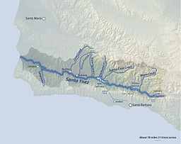
Map of the Santa Ynez River watershed
|
|
The Santa Ynez River is one of the largest rivers on the Central Coast of California. It is 92 miles (148 km) long, flowing from east to west through the Santa Ynez Valley, reaching the Pacific Ocean at Surf, near Vandenberg Air Force Base and the city of Lompoc.
The river drains the north slope of the Santa Ynez Mountains, the south slope of the San Rafael Mountains, as well as much of the southern half of Santa Barbara County. Its drainage basin is 896 square miles (2,320 km2) in area. The river's flow is highly variable. It usually dries up almost completely in the summer, but can become a raging torrent in the winter. The river has three dams which can impound a total of 210,000 acre feet (260,000,000 m3) of water in wet years.
The river was first named by the Spanish Portolà expedition, first European land exploration of Alta California, which camped near the river mouth on August 30, 1769. Apparently unable to agree on a single name, expedition diarists recorded three. Engineer Miguel Costanso wrote "Río Grande de San Verardo". Franciscan missionary Juan Crespi noted two additional names; "San Bernardo" and "Santa Rosa". None of the three names remain attached to any feature in the area.
Instead, the river and mountains took the name of Mission Santa Inés (also spelled "Ynés" or "Ynéz" in New Spain), which was established in 1804 (named for Saint Agnes of Rome, Virgin and Martyr). According to the USGS, variant and historical names of the Santa Ynez River include La Purisima River, Rio De La Purisima, Rio De Calaguasa, Rio Santa Rosa, Rio De Santa Ines, and Rio De Santa Ynes.
...
Wikipedia


