Gorman, California
| Gorman | |
|---|---|
| Unincorporated community | |

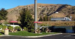
Gorman, California, from the west side of Interstate 5, which is marked by the white truck.
|
|
 Location of Gorman in Los Angeles County, California |
|
| Coordinates: 34°47′46″N 118°51′06″W / 34.79611°N 118.85167°WCoordinates: 34°47′46″N 118°51′06″W / 34.79611°N 118.85167°W | |
| Country | |
| State |
|
| County | Los Angeles |
| Area | |
| • Total | 6.19169 km2 (2.390625 sq mi) |
| Time zone | Pacific (UTC-8) |
| • Summer (DST) | Pacific Daylight Time (UTC-7) |
| ZIP code | 93243 |
| Area code(s) | 661 |
Gorman is an unincorporated community in northwestern Los Angeles County. Tens of thousands of motorists travel through it daily on Interstate 5.
Gorman is a historic travel stop in Peace Valley, at the Tejon Pass which links Southern California with the San Joaquin Valley and Northern California.
Gorman is 1,530 acres (6.2 km2) in size. It lies where three Transverse System mountain ranges meet — the Sierra Pelona Mountains, the Tehachapi Mountains, and the San Emigdio Mountains.
One of the Mountain Communities of the Tejon Pass, it is southeast of Frazier Park and south of Lebec. Interstate 5 runs through Gorman, and State Route 138 connects to the Interstate a few miles south.
California poppies, Lupines, and other wildflowers dramatically cover the hills in the springtime when there is sufficient rain.
The U.S. Census Bureau does not break out separate population figures for this small place, but in 2005 Gorman had only 15 homes and approximately a dozen registered voters.
Gorman is “one of the oldest continuously used trail and roadside rest stops in California,” as the Native Americans of California “would have stopped there when it was the Tataviam village of Kulshra’jek ” explains Mountain Communities historian Bonnie Ketterl Kane.
...
Wikipedia
