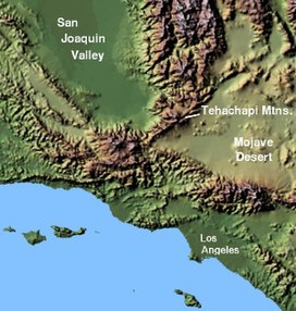
Tehachapi Mountains
| Tehachapi Mountains | |
|---|---|

Tehachapi Mountains Crest peaks
|
|
| Highest point | |
| Peak | Double Mountain |
| Elevation | 7,981 ft (2,433 m) |
| Dimensions | |
| Length | 40 mi (64 km) |
| Geography | |
| Country | United States |
| State | California |
| Counties | Kern and Los Angeles |
| Range coordinates | 34°57′N 118°35′W / 34.95°N 118.58°WCoordinates: 34°57′N 118°35′W / 34.95°N 118.58°W |
| Parent range | Transverse Ranges |
| Borders on | Sierra Nevada, San Emigdio Mountains and Sierra Pelona Mountains |
The Tehachapi Mountains /təˈhætʃəpi/ are a mountain range in the Transverse Ranges system of California in the Western United States. The range extends for approximately 40 miles (64 km) in southern Kern County and northwestern Los Angeles County.
The Tehachapis form a geographic, watershed, habitat, and rain shadow divide separating the San Joaquin Valley to the northwest and the Mojave Desert to the southeast. The Tehachapis' crest varies in height from approximately 4,000–8,000 feet (1,200–2,400 m). They are southeast of Bakersfield and the Central Valley, and west of Mojave and the Antelope Valley. The range runs southwest to northeast (SW-NE) connecting the Southern Sierra Nevada range on their northeast with the San Emigdio Mountains on the west and Sierra Pelona Mountains on the southwest.
The Tehachapis are delineated from the San Emigdio Mountains by Tejon Pass at the range's western end. The dramatic incline of Interstate 5 from the San Joaquin Valley floor up to the pass, is regionally referred to as The Grapevine, after Grapevine Canyon which it follows between the northern slopes of the two mountain ranges. The canyon was named after native grapevines, the California grapevine (Vitis californica), found at springs on its slopes. The California State Water Project is to the east, with the California Aqueduct pumped by the Edmonston Pumping Plant over/through the Tehachapis to Castaic Lake reservoir.
...
Wikipedia

