U.S. Route 54 (Kansas)
| U.S. Route 54 | |
|---|---|
 |
|
| Route information | |
| Length: | 1,197 mi (1,926 km) |
| Existed: | 1926 – present |
| Major junctions | |
| West end: |
|
|
|
| East end: |
|
| Location | |
| States: | Texas, New Mexico, Oklahoma, Kansas, Missouri, Illinois |
| Highway system | |
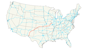
U.S. Route 54 (US 54) is an east–west United States highway that runs northeast-southwest for 1,197 miles (1,926 km) from western Illinois to El Paso, Texas. It enters and leaves Texas twice. The Union Pacific Railroad's Tucumcari Line (former Southern Pacific and Rock Island Lines "Golden State Route") runs parallel to US-54 from El Paso to Pratt, Kansas, which comprises about two-thirds of the route.
As of 2004, the highway's eastern terminus is Griggsville, Illinois, at Interstate 72 and Illinois Route 107. Its western terminus is El Paso, near the United States-Mexico border.
US 54 begins in El Paso at Loop 375 downtown. (US 54/Patriot Freeway) The highway serves as a major freeway for the Metro area's network, running north-south along the city's eastern slope of the Franklin Mountains range. The highway runs through the city for approximately 20 miles (32 km) before reaching the New Mexico state line. Within the network, it is a military connector for Fort Bliss and Holloman Air Force Base.
...
Wikipedia

