Stratford, Texas
| Stratford, Texas | |
|---|---|
| City | |

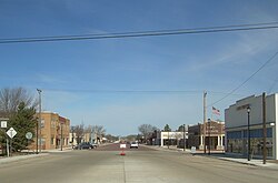
Stratford, 2006
|
|
 Location of Stratford, Texas |
|
 |
|
| Coordinates: 36°20′10″N 102°4′17″W / 36.33611°N 102.07139°WCoordinates: 36°20′10″N 102°4′17″W / 36.33611°N 102.07139°W | |
| Country | United States |
| State | Texas |
| County | Sherman |
| Area | |
| • Total | 2.0 sq mi (5.3 km2) |
| • Land | 2.0 sq mi (5.3 km2) |
| • Water | 0.0 sq mi (0.0 km2) |
| Elevation | 3,691 ft (1,125 m) |
| Population (2010) | |
| • Total | 2,017 |
| • Density | 1,000/sq mi (380/km2) |
| Time zone | Central (CST) (UTC-6) |
| • Summer (DST) | CDT (UTC-5) |
| ZIP code | 79084 |
| Area code(s) | 806 |
| FIPS code | 48-70544 |
| GNIS feature ID | 1369263 |
Stratford is a city in Sherman County, Texas, United States. The population was 2,017 at the 2010 census, up from 1,991 in 2000. It is the county seat of Sherman County.
The city is named for Stratford, Virginia, the boyhood home of Robert Edward Lee, the Confederate commanding general.
Stratford is located at 36°20′10″N 102°4′17″W / 36.33611°N 102.07139°W (36.336158, -102.071451). According to the United States Census Bureau, the city has a total area of 2.0 square miles (5.3 km²), all of it land.
As of the census of 2000, there were 1,991 people, 722 households, and 535 families residing in the city. The population density was 980.2 people per square mile (378.7/km²). There were 794 housing units at an average density of 390.9/sq mi (151.0/km²). The racial makeup of the city was 83.02% White, 0.30% African American, 0.65% Native American, 0.05% Asian, 14.41% from other races, and 1.56% from two or more races. Hispanic or Latino of any race were 30.44% of the population.
...
Wikipedia
