Nevada, Missouri
| Nevada, Missouri | |
|---|---|
| City | |
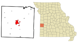
 Location within Vernon County and Missouri |
|
| Coordinates: 37°50′27″N 94°21′20″W / 37.84083°N 94.35556°WCoordinates: 37°50′27″N 94°21′20″W / 37.84083°N 94.35556°W | |
| Country | United States |
| State | Missouri |
| County | Vernon |
| Area | |
| • Total | 9.06 sq mi (23.47 km2) |
| • Land | 8.98 sq mi (23.26 km2) |
| • Water | 0.08 sq mi (0.21 km2) |
| Elevation | 873 ft (266 m) |
| Population (2010) | |
| • Total | 8,386 |
| • Estimate (2012) | 8,171 |
| • Density | 930/sq mi (360/km2) |
| Time zone | Central (CST) (UTC-6) |
| • Summer (DST) | CDT (UTC-5) |
| ZIP code | 64772 |
| Area code(s) | 417 |
| FIPS code | 29-51644 |
| GNIS feature ID | 0729934 |
| Website | http://nevadamo.gov/ |
Nevada /nəˈveɪdə/ (local pronunciation is NevAYda) is a city and a county seat of Vernon County, Missouri, United States. The population was 8,386 at the 2010 census, and 8,171 in the 2012 estimate. Nevada is the home of Cottey College.
Nevada was originally called "Hog Eye", and under the latter name was platted in 1855. The town's name was changed to Nevada after Nevada City, California by circuit and county clerk DeWitt C. Hunter, for the city where he had been a miner.
Nevada was home of the Weltmer Institute of Suggestive Therapeutics from 1897−1933. During the early 20th century, the business this healing institution generated was a driving force in the growing prosperity of the town.
The Carrington Osage Village Site, Infirmary Building, Missouri State Hospital Number 3, Vernon County Courthouse, and Vernon County Jail, Sheriff's House and Office are listed on the National Register of Historic Places.
Nevada is located at 37°50′27″N 94°21′20″W / 37.84083°N 94.35556°W (37.840930, -94.355576). According to the United States Census Bureau, the city has a total area of 9.06 square miles (23.47 km2), of which 8.98 square miles (23.26 km2) is land and 0.08 square miles (0.21 km2) is water.
...
Wikipedia
