U.S. Route 26 in Wyoming
| U.S. Route 26 | |
|---|---|
 |
|
| Route information | |
| Length: | 1,485 mi (2,390 km) |
| Existed: | 1926 – present |
| Major junctions | |
| West end: |
|
|
|
| East end: |
|
| Location | |
| States: | Oregon, Idaho, Wyoming, Nebraska |
| Highway system | |
| U.S. Highway 320 | |
|---|---|
| Location: | Shoshoni–Riverton |
| Existed: | 1926–1938 |
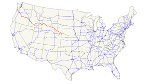
U.S. Route 26 is an east–west United States highway. It started in Ogallala, Nebraska, and gradually grew to reach the West Coast in Oregon. When the U.S. highway system was first defined, it was limited to Nebraska and Wyoming; by the 1950s, it continued into Idaho and Oregon. The highway's eastern terminus is in Ogallala, Nebraska at an intersection with Interstate 80. Its western terminus is south of Seaside, Oregon at an intersection with U.S. Route 101. Prior to 2004, the route's last 20 miles (32 km) were co-signed with U.S. Route 101 from the highways' junction south of Seaside north to Astoria where its intersection with U.S. Route 30 was also U.S. 30's western terminus.
Much of the highway follows the path of the historic Oregon Trail. At its peak, immediately before the establishment of the interstate highway system, US 26 was 1,557 miles (2506 km) in length, and terminated in Astoria, Oregon.
Starting at a junction with U.S. Highway 101 near Seaside, Oregon, U.S. Highway 26 heads southeast through the Coast Range to Portland. In the western Portland area, US 26 is a freeway known as the Sunset Highway. After passing through the Vista Ridge Tunnel, heading into downtown Portland, it intersects with Interstate 405 and runs along the interstate southbound for about a half-mile before exiting onto surface streets at the waterfront, meeting Oregon Route 43 at Macadam Avenue before crossing Interstate 5. After crossing the Willamette River and meeting at an incomplete interchange with Oregon Route 99E, US26 then heads east on Powell Boulevard where it crosses Interstate 205 and continues east to Sandy on what is known as the Mount Hood Highway No. 26 (see Oregon Routes and Highways), a four-lane divided highway that was supposed to be the Mount Hood Freeway, which was never built just south of Division St.
...
Wikipedia

