Willamette River
| Willamette River | |
|
The Willamette passing through Downtown Portland in a photo from the 1980s
|
|
| Name origin: From a Clackamas Native American village name | |
| Country | United States |
|---|---|
| State | Oregon |
| Tributaries | |
| - left | Coast Fork Willamette River, Long Tom River, Marys River, Luckiamute River, Yamhill River, Tualatin River |
| - right | Middle Fork Willamette River, McKenzie River, Calapooia River, Santiam River, Molalla River, Clackamas River |
| Cities | Eugene, OR, Corvallis, OR, Albany, OR, Salem, OR, Newberg, OR, Wilsonville, OR, Portland, OR |
| Source | Confluence of Middle Fork Willamette River and Coast Fork Willamette River |
| - location | near Eugene, Lane County, Oregon |
| - elevation | 438 ft (134 m) |
| - coordinates | 44°01′23″N 123°01′25″W / 44.02306°N 123.02361°W |
| Mouth | Columbia River |
| - location | Portland, Multnomah County, Oregon |
| - elevation | 10 ft (3 m) |
| - coordinates | 45°39′10″N 122°45′53″W / 45.65278°N 122.76472°WCoordinates: 45°39′10″N 122°45′53″W / 45.65278°N 122.76472°W |
| Length | 187 mi (301 km) |
| Basin | 11,478 sq mi (29,730 km2) |
| Discharge | for Morrison Bridge, Portland, 12.8 miles (20.6 km) from mouth |
| - average | 33,010 cu ft/s (900 m3/s) |
| - max | 420,000 cu ft/s (11,900 m3/s) |
| - min | 4,200 cu ft/s (100 m3/s) |
|
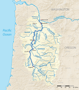
A map of the Willamette River, its drainage basin, major tributaries and major cities
|
|
The Willamette River (![]() i/wᵻˈlæmᵻt/ wil-LAM-it) is a major tributary of the Columbia River, accounting for 12 to 15 percent of the Columbia's flow. The Willamette's main stem is 187 miles (301 km) long, lying entirely in northwestern Oregon in the United States. Flowing northward between the Oregon Coast Range and the Cascade Range, the river and its tributaries form the Willamette Valley, a basin that contains two-thirds of Oregon's population, including the state capital, Salem, and the state's largest city, Portland, which surrounds the Willamette's mouth at the Columbia.
i/wᵻˈlæmᵻt/ wil-LAM-it) is a major tributary of the Columbia River, accounting for 12 to 15 percent of the Columbia's flow. The Willamette's main stem is 187 miles (301 km) long, lying entirely in northwestern Oregon in the United States. Flowing northward between the Oregon Coast Range and the Cascade Range, the river and its tributaries form the Willamette Valley, a basin that contains two-thirds of Oregon's population, including the state capital, Salem, and the state's largest city, Portland, which surrounds the Willamette's mouth at the Columbia.
Originally created by plate tectonics about 35 million years ago and subsequently altered by volcanism and erosion, the river's drainage basin was significantly modified by the Missoula Floods at the end of the most recent ice age. Humans began living in the watershed over 10,000 years ago. There were once many tribal villages along the lower river and in the area around its mouth on the Columbia. Indigenous peoples lived throughout the upper reaches of the basin as well.
...
Wikipedia


