McKenzie River (Oregon)
| McKenzie River | |
|
An island in the upper McKenzie
|
|
| Country | United States |
|---|---|
| State | Oregon |
| Counties | Lane, Linn |
| Source | Clear Lake |
| - location | Cascade Range, Linn County |
| - elevation | 3,570 ft (1,088 m) |
| - coordinates | 44°21′37″N 121°59′39″W / 44.36028°N 121.99417°W |
| Mouth | Willamette River |
| - location | Lane County |
| - elevation | 371 ft (113 m) |
| - coordinates | 44°7′32″N 123°6′20″W / 44.12556°N 123.10556°WCoordinates: 44°7′32″N 123°6′20″W / 44.12556°N 123.10556°W |
| Length | 90 mi (145 km) |
| Basin | 1,300 sq mi (3,367.0 km2) |
| Discharge | for river mile 7.2 at Armitage Bridge near Coburg |
| - average | 5,905 cu ft/s (167 m3/s) |
| - max | 88,200 cu ft/s (2,498 m3/s) |
| - min | 1,080 cu ft/s (31 m3/s) |
|
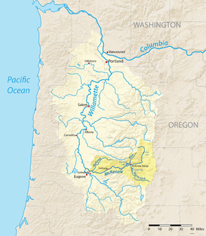
Map of the Willamette River basin with the McKenzie River highlighted
|
|
The McKenzie River is a 90-mile (145 km) tributary of the Willamette River in western Oregon in the United States. It drains part of the Cascade Range east of Eugene and flows westward into the southernmost end of the Willamette Valley. It is named for Donald Mackenzie, a Scottish Canadian fur trader who explored parts of the Pacific Northwest for the Pacific Fur Company in the early 19th century. As of the 21st century, six large dams have been built on the McKenzie and its tributaries.
The McKenzie River originates as the outflow of Clear Lake in the high Cascades of eastern Linn County in the Willamette National Forest. (Clear Lake is fed by Ikenick Creek and Fish Lake Creek, the latter of which flows from Fish Lake. Fish Lake's main tributary is Hackleman Creek, which drains the north side of Browder Ridge east of Tombstone Pass. U.S. Route 20 crosses the pass and follows Hackleman Creek.) The McKenzie River flows south from Clear Lake, paralleled by Oregon Route 126, and goes over the Sahalie and Koosah waterfalls to Carmen Reservoir, a man-made lake from which the river is then diverted into a 2-mile (3.2 km) tunnel to Smith Reservoir. Between Carmen Reservoir and Tamolitch Falls, the riverbed is dry for 3 miles (4.8 km) because lava from Belknap Crater buried that stretch of the river about 1,600 years ago. The river flows under the lava for those three miles and re-surfaces at Tamolitch Pool at the base of Tamolitch Falls. It then flows south into Trail Bridge Reservoir, where the Smith River enters from the . After passing through Trail Bridge Dam, the river enters Lane County. The McKenzie continues south to Belknap Springs, where it turns west and flows past the community of McKenzie Bridge. It receives the South Fork McKenzie River about three miles east of Blue River. (The South Fork rises near the Pacific Crest Trail in the Three Sisters Wilderness and flows north-northwest for about 30 miles (48 km) through Cougar Reservoir and Cougar Dam.)
...
Wikipedia


