*** Welcome to piglix ***

Columbia River

Columbia River
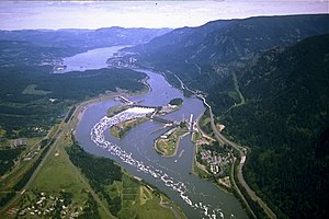
Aerial view of a large river winding through a mountainous gorge. It passes over a dam stretching in four segments from bank to bank across three intervening islands. Highways, passing by clusters of buildings here and there on both banks, run parallel to the river. Whitewater and foam curl downriver from one of the central segments.
Bonneville Dam, in the Columbia River Gorge
Name origin: Captain Robert Gray's ship, Columbia Rediviva
Nickname: Big River, the River of the West, River Oregon
Countries United States, Canada
States Washington, Oregon
Province British Columbia
Tributaries
 - left Spillimacheen River, Beaver River, Illecillewaet River, Incomappleux River, Kootenay River, Pend Oreille River, Spokane River, Snake River, John Day River, Deschutes River, Willamette River
 - right Kicking Horse River, Blaeberry River, Canoe River, Kettle River, Sanpoil River, Okanogan River, Entiat River, Wenatchee River, Yakima River, Lewis River, Cowlitz River
Cities Revelstoke, BC, Wenatchee, WA, Tri-Cities, WA, The Dalles, OR, Hood River, OR, Portland, OR, Vancouver, WA, Longview, WA, Astoria, OR
Source Columbia Lake
 - location British Columbia, Canada
 - elevation 2,690 ft (820 m)
 - coordinates 50°13′35″N 115°51′05″W / 50.22639°N 115.85139°W / 50.22639; -115.85139 
Mouth Pacific Ocean, at Clatsop County, Oregon / Pacific County, Washington
 - elevation 0 ft (0 m)
 - coordinates 46°14′39″N 124°3′29″W / 46.24417°N 124.05806°W / 46.24417; -124.05806Coordinates: 46°14′39″N 124°3′29″W / 46.24417°N 124.05806°W / 46.24417; -124.05806 
Length 1,243 mi (2,000 km)
Basin 258,000 sq mi (668,000 km2)
Discharge for mouth (average); max and min at The Dalles, Oregon, 188.9 miles (304.0 km) from the mouth
 - average 265,000 cu ft/s (7,500 m3/s)
 - max 1,240,000 cu ft/s (35,100 m3/s)
 - min 12,100 cu ft/s (300 m3/s)
Three-color map of the Columbia River watershed. The watershed is shaped roughly like a funnel with its wide end to the east and its narrow end along the border between Washington and Oregon as it nears the Pacific Ocean. The watershed extends into the western US states of Washington, Oregon, Idaho, Nevada, Utah, Wyoming, and Montana, and the western Canadian province of British Columbia as far east as its border with Alberta. The river itself makes a hairpin turn from north-west to south in British Columbia and another sharp turn from south to west as it nears Oregon.
Columbia River drainage basin

The Columbia River is the largest river in the Pacific Northwest region of North America. The river rises in the Rocky Mountains of British Columbia, Canada. It flows northwest and then south into the US state of Washington, then turns west to form most of the border between Washington and the state of Oregon before emptying into the Pacific Ocean. The river is 1,243 miles (2,000 km) long, and its largest tributary is the Snake River. Its drainage basin is roughly the size of France and extends into seven US states and a Canadian province.

By volume, the Columbia is the fourth-largest river in the United States; it has the greatest flow of any North American river draining into the Pacific. The river's heavy flow and relatively steep gradient gives it tremendous potential for the generation of electricity. The 14 hydroelectric dams on the Columbia's main stem and many more on its tributaries produce more than 44 percent of total U.S. hydroelectric generation – much more hydroelectric power than those of any other North American river.

The Columbia and its tributaries have been central to the region's culture and economy for thousands of years. They have been used for transportation since ancient times, linking the many cultural groups of the region. The river system hosts many species of anadromous fish, which migrate between freshwater habitats and the saline waters of the Pacific Ocean. These fish—especially the salmon species—provided the core subsistence for native peoples; in past centuries, Indigenous peoples traveled across western North America to the Columbia to trade for fish.

In the late 18th century, a private American ship became the first non-indigenous vessel to enter the river; it was followed by a British explorer, who navigated past the Oregon Coast Range into the Willamette Valley. In the following decades, fur trading companies used the Columbia as a key transportation route. Overland explorers entered the Willamette Valley through the scenic but treacherous Columbia River Gorge, and pioneers began to settle the valley in increasing numbers, following both routes to enter it. Steamships along the river linked communities and facilitated trade; the arrival of railroads in the late 19th century, many running along the river, supplemented these links.


...
Wikipedia

...