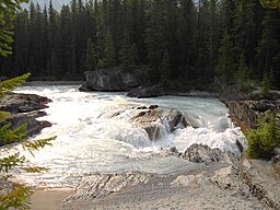
Kicking Horse River
| Kicking Horse River | |
|
Kicking Horse River
|
|
| Country | Canada |
|---|---|
| Province | British Columbia |
| Source | Wapta Lake |
| - location | Hector, Yoho National Park |
| Mouth | Columbia River |
| - location | Golden |
| - coordinates | 51°18′N 116°59′W / 51.300°N 116.983°WCoordinates: 51°18′N 116°59′W / 51.300°N 116.983°W |
| Discharge | for near Golden |
| - average | 40.9 m3/s (1,444 cu ft/s) |
| - max | 402 m3/s (14,196 cu ft/s) |
| - min | 2.25 m3/s (79 cu ft/s) |
The Kicking Horse River is in the Canadian Rockies of southeastern British Columbia, Canada. The river was named in 1858, when James Hector, a member of the Palliser Expedition, reported being kicked by his packhorse while exploring the river. Hector named the river and the associated pass as a result of the incident. The Kicking Horse Pass, which connects through the Rockies to the valley of the Bow River, was the route through the mountains subsequently taken by the Canadian Pacific Railway when it was constructed during the 1880s. The railway's Big Hill and associated Spiral Tunnels are in the Kicking Horse valley and were necessitated by the steep rate of descent of the river and its valley.
Kicking Horse Pedestrian Bridge in Golden is the longest authentic covered timber-frame bridge in Canada. Planned as a community project by the Timber Framers Guild, local volunteers were joined by carpenters and timber framers from Canada, the United States and Europe. The bridge structure is 150 feet (46 m) long, with a 210,000-pound (95,000 kg) Burr arch structure. The bridge was completed in September 2001.
The Trans-Canada Highway traverses the river at several points from Yoho National Park to Golden, British Columbia. The river is spanned by the new Park Bridge. Kicking Horse Mountain Resort, named for the river and pass, is located not in the Canadian Rockies but across the Rocky Mountain Trench in the Dogtooth Range of the Purcell Mountains, on the other side of the town of Golden.
...
Wikipedia

