Yoho National Park
| Yoho National Park | |
|---|---|
|
IUCN category II (national park)
|
|

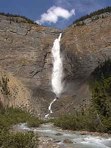
Takakkaw Falls
|
|
| Location of Yoho National Park | |
| Location | British Columbia, Canada |
| Nearest city | Golden |
| Coordinates | 51°23′43″N 116°29′12″W / 51.39528°N 116.48667°WCoordinates: 51°23′43″N 116°29′12″W / 51.39528°N 116.48667°W |
| Area | 1,313 km2 (507 sq mi) |
| Established | October 10, 1886 |
| Governing body | Parks Canada |
| World Heritage Site | 304 |
Yoho National Park is located in the Canadian Rocky Mountains along the western slope of the Continental Divide of the Americas in southeastern British Columbia. Yoho NP is bordered by Kootenay National Park on the southern side and Banff National Park on the eastern side in Alberta. The name Yoho comes from the Cree word for awe and wonder.
Yoho covers 1,313 km2 (507 mi2) and it is the smallest of the four contiguous national parks. Yoho, together with Jasper, Kootenay and Banff National Parks, along with three British Columbia provincial parks—Hamber Provincial Park, Mount Assiniboine Provincial Park, and Mount Robson Provincial Park—form the Canadian Rocky Mountain Parks World Heritage Site. The park's administrative and visitor centre are located in the town of Field, British Columbia, beside the Trans-Canada Highway.
The park was created following a trip by Prime Minister John A. Macdonald and his wife Agnes through the Rockies on the newly completed Trancontinental Railway. Inspired on his return to Ottawa, Yoho National Park was created on October 10, 1886. Glacier National Park was created on the same day, becoming the second and third national parks in the country, after Banff.
...
Wikipedia

