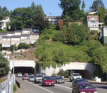
Vista Ridge Tunnel

The east end of the Vista Ridge Tunnels face downtown Portland and are under a residential neighborhood.
|
|
| Overview | |
|---|---|
| Location | Portland, Oregon, USA |
| Coordinates |
45°30′57″N 122°41′57″W / 45.5158°N 122.6991°WCoordinates: 45°30′57″N 122°41′57″W / 45.5158°N 122.6991°W (west) 45°30′56″N 122°41′41″W / 45.5156°N 122.6948°W (east) |
| Status | operational |
| Route |
|
| Operation | |
| Opened | 1969–1970 |
| Owner | Oregon Department of Transportation |
| Traffic | Automotive |
| Character | Limited access highway |
| Technical | |
| No. of lanes | 6, 3 in each bore |
| Operating speed | 50 mph (80 km/h) |
The Vista Ridge Tunnels are highway tunnels through the Tualatin Mountains ("West Hills") of Portland, Oregon, United States. Located in the Goose Hollow neighborhood, the tunnels pass through a hillside locally known as Vista Ridge which is a half mile (1 km) west of downtown Portland. Sunset Highway, also known as U.S. Route 26, is carried through the tunnels, three lanes in each direction. They are Oregon's busiest tunnels.
The eastbound tunnel is 1001.0 feet (305 m) in length; the westbound tunnel is 949 feet (289 m). Both have 41 ft (12.5 m) of horizontal and 15.58 ft (4.75 m) of vertical clearance. The eastbound tunnel was completed in 1969, the westbound a year later.
There is a six-percent grade through the tunnels. Most of the tunnels' lengths are straight, though they curve southward at the west ends 35°.
The tunnels were built with ventilation shafts which were never used. Instead, the shafts were later adapted for electrical wiring, so as to improve tunnel illumination without marring the tunnels' appearance with visible conduit.
To improve tunnel safety for motorists, and decrease the tunnel lighting requirements, the original tunnel entrance faces were sandblasted to remove white paint and repainted a less luminescent tan color to reduce the range of visual light adaptation required by drivers. At one time there were computer-based electronic light controls, but they were replaced by relatively simple photo detectors and relays for durability and simplicity. The night lighting level is enabled permanently and is supplemented by two or three levels of daytime lighting.
Except directly over the tunnels, the hillsides are steep and undeveloped forest, with some residential development along the top of the ridges. Landslides occasionally occur, but are usually minor and quickly cleared.
The tunnels have been closed to hazardous material transport since November 1, 1994. As a result, US 26 is closed to hazardous material transport between I-405 and Oregon Route 217.
...
Wikipedia
