Casper, Wyoming
|
Casper, Wyoming Pahášaša Otȟúŋwahe |
|
|---|---|
| City | |
| City of Casper | |

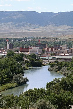
Overview of downtown Casper, looking south toward Casper Mountain, with North Platte River in foreground.
|
|
| Nickname(s): "The Oil City" | |
 Location in Wyoming |
|
| Location in the United States | |
| Coordinates: 42°51′0″N 106°19′30″W / 42.85000°N 106.32500°WCoordinates: 42°51′0″N 106°19′30″W / 42.85000°N 106.32500°W | |
| Country | United States |
| State | Wyoming |
| County | Natrona |
| Government | |
| • City Manager | V.H. McDonald |
| Area | |
| • City | 27.24 sq mi (70.55 km2) |
| • Land | 26.90 sq mi (69.67 km2) |
| • Water | 0.34 sq mi (0.88 km2) |
| • Metro | 5,376 sq mi sq mi (13,923 km² km2) |
| Elevation | 5,150 ft (1,560 m) |
| Population (2010) | |
| • City | 55,316 |
| • Estimate (2014) | 60,086 |
| • Rank | US: 601st |
| • Density | 2,056.4/sq mi (794.0/km2) |
| • Urban | 64,548 (US: 424th) |
| • Metro | 81,624 (US: 376th) |
| Time zone | MST (UTC-7) |
| • Summer (DST) | MDT (UTC-6) |
| ZIP codes | 82601, 82602, 82604, 82605, 82609, 82615, 82630, 82638, 82646 |
| Area code(s) | 307 |
| FIPS code | 56-13150 |
| GNIS feature ID | 1586424 |
| Website | www.casperwy.gov |
Casper (Lakota: Pahášaša Otȟúŋwahe; "Red Hill City") is a city in and the county seat of Natrona County, Wyoming, United States. Casper is the second-largest city in Wyoming, according to the 2010 census, with a population of 55,316. Only Cheyenne, the state capital, is larger. Casper is nicknamed "The Oil City" and has a long history of oil boomtown and cowboy culture, dating back to the development of the nearby Salt Creek Oil Field. In 2010, Casper was named the highest-ranked family-friendly small city in the West, and ranked eighth overall in the nation in Forbes magazine's list of "the best small cities to raise a family".
Casper is located in east-central Wyoming at the foot of Casper Mountain, the north end of the Laramie Mountain Range, along the North Platte River.
The city was established east of the former site of Fort Caspar, which was built during the mid-19th century mass migration of land seekers along the Oregon, California and Mormon trails. The area was the location of several ferries that offered passage across the North Platte River in the early 1840s. In 1859, Louis Guinard built a bridge and trading post near the original ferry locations.
The government soon posted a military garrison nearby to protect telegraph and mail service. It was under the command of Lieutenant Colonel William O. Collins.American Indian attacks increased after the Sand Creek Massacre in Colorado in 1864, bringing more troops to the post, which was by now called Platte Bridge Station. In July 1865, Lieutenant Caspar Collins (the son of Colonel Collins) was killed near the post by a group of Indian warriors. Three months later the garrison was renamed Fort Caspar after Lieutenant Collins. In 1867, the troops were ordered to abandon Fort Caspar in favor of Fort Fetterman downstream on the North Platte along the Bozeman Trail.
...
Wikipedia

