Tanah Merah, Singapore
| Tanah Merah | |||
|---|---|---|---|
| Other transcription(s) | |||
| • Chinese | 丹那美拉 | ||
| • Pinyin | Dānnàměilā | ||
| • Malay | Tanah Merah | ||
| • Tamil | தானா மேரா | ||
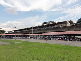
Exterior of Tanah Merah MRT Station, located at the epicenter of the region
|
|||
 Rough extent of Tanah Merah along the eastern coast of Singapore |
|||
| Coordinates: 1°18′51.47″N 103°56′50.33″E / 1.3142972°N 103.9473139°E | |||
| Country |
|
||
| Region | East Region | ||
| Main composition |
4 planning areas
|
||
Tanah Merah (Chinese: 丹那美拉 Tamil: தானா மேரா), is a geographical region located along the south-eastern coast of the East Region of Singapore. Although its boundaries aren't exactly clear, it is often widely accepted that term "Tanah Merah", is used to refer to the southern coast of present-day Bedok, Tampines, Changi and Changi Bay.
The name "Tanah Merah" appears in the seventeenth century (1604) map by Manuel Gomes de Erédia on Singapore, and is referred as Tana Mera. This place name is likely to have been an important reference point for the orang laut (sea Gypsies) in their activities in the region.
The Malay name for this area is probably derived from British references to this area based on the various surveys done. The name is derived from the red lateritic cliffs along the coast that were visible from the sea, hence the name Tanah Merah or "red land". The earliest written reference comes from James Horsburgh's 1806 chart of "Singapore and Malacca", which has the name "Red Cliffs". Later, two sets of red cliffs were identified in Franklin and Jackson's 1830 map: "Large Red Cliff" (Tanah Merah area) and "Small Red Cliff" (present Bedok area) and "2nd Red Cliffs" (Tanah Merah area). J.E. Tassin's 1836 Map of Singapore refers to the area as "1st Red Cliffs" (Bedok area) and "2nd Red Cliffs" (Tanah Merah area). While the other place names in Singapore were mentioned by their Malay names in the above maps, this area was recorded by its English reference, which shows that it had not as yet been given a local name.
Old maps also show the existence of Tanah Merah Road as early as the 1840s, which stretched from Kallang River to Changi Point. Now, the road ran mostly along the original route but was renamed Geylang Road, Changi Road and Upper Changi Road, with a section between Siglap Road and Tanah Merah Kechil Road lost after the hills of Chai Chee and Bedok were levelled, and another short section lost under Changi Airport. Later, the road leading to "Large Red Cliff" was named "Tanah Merah Besar Road" while the other was named "Tanah Merah Kechil Road". Besar means "large" while Kechil means "little" in Malay.
...
Wikipedia

