Bedok
| Bedok | ||||||||
|---|---|---|---|---|---|---|---|---|
| Planning Area and HDB Town | ||||||||
| Other transcription(s) | ||||||||
| • Chinese | 勿洛 | |||||||
| • Pinyin | Wù luò | |||||||
| • Hokkien | Bût-lo̍k | |||||||
| • Malay | Bedok | |||||||
| • Tamil | பிடோக் | |||||||
| • Tamil romanisation | Piṭōk | |||||||
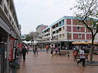
From top left to right: Panoramic view of Bedok Reservoir, Bedok Stadium, Bedok Reservoir Estate, Bedok Town Centre, Bedok Jetty, Bedok Bus Interchange
|
||||||||
| Location of Bedok in Singapore | ||||||||
| Coordinates: 1°19′24.96″N 103°55′38.42″E / 1.3236000°N 103.9273389°E | ||||||||
| Country |
|
|||||||
| Region |
|
|||||||
| CDCs | ||||||||
| Town councils |
|
|||||||
| Constituencies | ||||||||
| DGP exhibited |
|
|||||||
| PA incorporated |
|
|||||||
| Government | ||||||||
| • Mayors |
North East CDC South East CDC |
|||||||
| • Members of Parliament |
Aljunied GRC East Coast GRC Fengshan SMC Marine Parade GRC |
|||||||
| Area | ||||||||
| • Total | 21.69 km2 (8.37 sq mi) | |||||||
| Area rank | 7th | |||||||
| • Residential | 4.18 km2 (1.61 sq mi) | |||||||
| Population (2015) | ||||||||
| • Total | 289,750 | |||||||
| • Rank | 1st | |||||||
| • Density | 13,360.5/km2 (34,604/sq mi) | |||||||
| • Density rank | 9th | |||||||
| Demonym(s) |
Official
Colloquial
|
|||||||
| Ethnic groups | ||||||||
| • Chinese | 208,880 | |||||||
| • Malays | 43,980 | |||||||
| • Indians | 25,110 | |||||||
| • Others | 11,780 | |||||||
| Postal district | 16 | |||||||
| Dwelling units | 60,115 | |||||||
| Projected ultimate | 79,000 | |||||||
North East CDC
South East CDC
Aljunied GRC
East Coast GRC
Fengshan SMC
Marine Parade GRC
Official
Colloquial
Bedok /bəˈdɒk/ (Chinese: 勿洛, Tamil: பிடோக்) is a planning area and matured residential town located in the East Region of Singapore. Population wise, Bedok is the largest planning area in the Republic, being home to an estimated 289,000 residents. This high demographic is largely explained by the affordable public housing in Bedok New Town, due to its relatively distant location from the Central Area. Besides public housing developments, private residences are also prevalent the area, most of which are found in the neighborhoods of Bayshore, Frankel and Siglap, in western and southwestern Bedok. Apart from the maritime boundary that the area shares with the Singapore Strait to the south and southeast, Bedok is also bounded by five other planning areas, they are Paya Lebar to the north, Hougang to the northwest, Tampines to the northeast and east, Geylang to the west and Marine Parade to the southwest.
As a part of the Tanah Merah region, the history of Bedok is largely influenced by its coastal frontier. The general area known as Bedok today, was first mentioned in maps dating to the pre-Raffles era. After Singapore was colonized by the British in 1819, Simpang Bedok Village became an ethnically mixed community consisting of Chinese and Malay peoples. Before the 1960s, Bedok's primary source of income was coconut, which was harvested from the plantations that were found in Siglap subzone. Fishing was also another primary source of income for the villagers of Simpang Bedok at the time.
...
Wikipedia


