State Route 23 (Ohio pre-1927)
| U.S. Route 20 | ||||
|---|---|---|---|---|

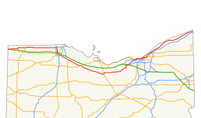
Route of US 20 in red across northern Ohio
|
||||
| Route information | ||||
| Maintained by ODOT | ||||
| Length: | 260.40 mi (419.07 km) | |||
| Existed: | 1926 – present | |||
| Major junctions | ||||
| West end: |
|
|||
|
|
||||
| East end: |
|
|||
| Location | ||||
| Counties: | Williams, Fulton, Lucas, Wood, Sandusky, Huron, Lorain, Cuyahoga, Lake, Ashtabula | |||
| Highway system | ||||
|
||||
U.S. Route 20 (US 20) is a United States Numbered Highway that runs from Newport, Oregon to Boston, Massachusetts. Within the state of Ohio, the route runs from the Indiana border near Edon to the Pennsylvania border at Conneaut. The route passes through rural areas west of Toledo, and passes through Public Square in Cleveland. It is one of 9 other routes to enter downtown Cleveland at Public Square, and it serves some of Cleveland's northeastern suburbs.
Prior to the establishment of the U.S. highway system in 1926, the general routing of US 20 was occupied by SR 23 from the Indiana state line to Toledo, SR 102 from Toledo to Woodville, and SR 2 from Woodville east to the Ohio-Pennsylvania border. The route has existed closely to its 1926 routing, except for two bypasses: one built around the north side of Fremont between 1957 and 1958, and a second built around the south side of Norwalk by 1967. By 1932 US 20 between Pioneer and Maumee had become US 20N and a US 20S designation had been created to the south between those points; by 1935 US 20N had reverted to US 20 and US 20S had become US 20A.
US 20 enters the state in Northwest Township, Williams County. The route parallels the Ohio Turnpike (Interstate 80/Interstate 90) through rural farmland in the northwest corner of the state. Within the city of Toledo, the route turns north-south along Reynolds Road, which becomes Conant Street as the route enters Maumee. After crosing the Maumee River into Perrysburg, US 20 continues through downtown Perrysburg, then angles southeasterly, becoming concurrent with US 23 until Woodville. US 20 continues southeasterly towards the bypass of Fremont, most of which is concurrent with US 6.
...
Wikipedia

