Lake County, Ohio
| Lake County, Ohio | ||
|---|---|---|

Lake County Courthouse
|
||
|
||
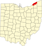
 Location in the U.S. state of Ohio |
||
 Ohio's location in the U.S. |
||
| Founded | March 6, 1840 | |
| Named for | Lake Erie | |
| Seat | Painesville | |
| Largest city | Mentor | |
| Area | ||
| • Total | 979 sq mi (2,536 km2) | |
| • Land | 227 sq mi (588 km2) | |
| • Water | 752 sq mi (1,948 km2), 77% | |
| Population | ||
| • (2010) | 230,041 | |
| • Density | 1,011/sq mi (390/km²) | |
| Congressional district | 14th | |
| Time zone | Eastern: UTC-5/-4 | |
| Website | www |
|
Lake County is a county located in the U.S. state of Ohio. As of the 2010 census, the population was 230,041. The county seat is Painesville. The county was established on March 6, 1840, from land given by Cuyahoga and Geauga Counties. Its name is derived from its location on the southern shore of Lake Erie.
Lake County is part of the Cleveland-Elyria, OH Metropolitan Statistical Area.
After the discovery of the New World, the land that became Lake County was originally part of the French colony of Canada (New France), which was ceded in 1763 to Great Britain and renamed Province of Quebec. In the late 18th century the land became part of the Connecticut Western Reserve in the Northwest Territory, then was purchased by the Connecticut Land Company in 1795.
According to the U.S. Census Bureau, the county has a total area of 979 square miles (2,540 km2), of which 227 square miles (590 km2) is land and 752 square miles (1,950 km2) (77%) is water. It is the smallest county in Ohio by land area but the third-largest by total area. It borders Ontario across Lake Erie.
In 2010, 92.4% spoke English, 2.7% Spanish, and 1.4% Croatian.
...
Wikipedia

