Shrewsbury Township, New Jersey
| Shrewsbury Township, New Jersey | |
|---|---|
| Township | |
| Township of Shrewsbury | |
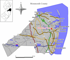
 Map of Shrewsbury Township in Monmouth County. Inset: Location of Monmouth County highlighted in the State of New Jersey. |
|
 Census Bureau map of Shrewsbury Township, New Jersey |
|
| Coordinates: 40°18′48″N 74°04′18″W / 40.313433°N 74.071686°WCoordinates: 40°18′48″N 74°04′18″W / 40.313433°N 74.071686°W | |
| Country |
|
| State |
|
| County | Monmouth |
| Formed | October 31, 1693 |
| Incorporated | February 21, 1798 |
| Named for | Shrewsbury, England |
| Government | |
| • Type | Township |
| • Body | Township Committee |
| • Mayor | Edward P. Nolan (R, term ends December 31, 2017) |
| • Clerk | Jan Delonardo |
| Area | |
| • Total | 0.105 sq mi (0.272 km2) |
| • Land | 0.105 sq mi (0.272 km2) |
| • Water | 0.000 sq mi (0.000 km2) 0.00% |
| Area rank | 566th of 566 in state 53rd of 53 in county |
| Elevation | 39 ft (12 m) |
| Population (2010 Census) | |
| • Total | 1,141 |
| • Estimate (2015) | 1,122 |
| • Rank | 529th of 566 in state 48th of 53 in county |
| • Density | 10,877.7/sq mi (4,199.9/km2) |
| • Density rank | 27th of 566 in state 2nd of 53 in county |
| Time zone | Eastern (EST) (UTC-5) |
| • Summer (DST) | Eastern (EDT) (UTC-4) |
| ZIP code | 07724 |
| Area code(s) | 732 |
| FIPS code | 3402567365 |
| GNIS feature ID | 0882603 |
| Website | www |
Shrewsbury Township is a township in Monmouth County, New Jersey, United States. As of the 2010 United States Census, the township's population was 1,141, reflecting an increase of 43 (+3.9%) from the 1,098 counted in the 2000 Census, which was unchanged from the 1,098 counted in the 1990 Census.
Shrewsbury was part of the Navesink Patent or Monmouth Tract granted soon after the creation of East Jersey in 1665.
When it was formed in 1693, Shrewsbury Township covered an area of almost 1,000 square miles (2,600 km2), extending to the north to the Navesink River, south to include all of present-day Ocean County, east to the Atlantic Ocean and west to the present-day border of Monmouth County. It retained its size and scope until 1750, when Stafford Township was formed, taking away most of present-day Ocean County. The Parker Homestead, one of the oldest buildings in state, was built by early settlers to the region.
What is now Shrewsbury Township was originally formed on October 31, 1693, and was created as a township by the Township Act of 1798 of the New Jersey Legislature on February 21, 1798.
Over the centuries, portions of the township have been taken to form Stafford Township (March 3, 1750), Dover Township (March 1, 1768, now Toms River Township), Howell Township (February 23, 1801), Ocean Township (February 24, 1849), Atlantic Township (February 18, 1847, now Colts Neck), Red Bank (March 17, 1870), Eatontown (April 4, 1873), Rumson (May 15, 1907),Fair Haven (March 28, 1912), Little Silver (March 19, 1923), Shrewsbury borough (March 22, 1926) and New Shrewsbury (April 15, 1950, now Tinton Falls). The township was named for Shrewsbury, England.
...
Wikipedia
