Rumson, New Jersey
| Rumson, New Jersey | ||
|---|---|---|
| Borough | ||
| Borough of Rumson | ||

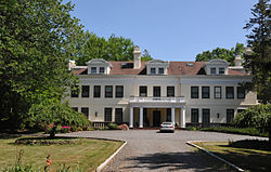
Lauriston
|
||
|
||
 Map of Rumson in Monmouth County. Inset: Location of Monmouth County highlighted in the State of New Jersey. |
||
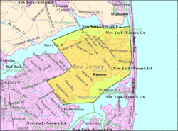
 Census Bureau map of Rumson, New Jersey |
||
| Coordinates: 40°21′43″N 74°00′18″W / 40.362°N 74.005°WCoordinates: 40°21′43″N 74°00′18″W / 40.362°N 74.005°W | ||
| Country |
|
|
| State |
|
|
| County | Monmouth | |
| Incorporated | June 18, 1907 | |
| Government | ||
| • Type | Borough | |
| • Body | Borough Council | |
| • Mayor | John E. Ekdahl (R, term ends December 31, 2019) | |
| • Administrator / Clerk | Thomas S. Rogers | |
| Area | ||
| • Total | 7.117 sq mi (18.432 km2) | |
| • Land | 5.058 sq mi (13.101 km2) | |
| • Water | 2.059 sq mi (5.332 km2) 28.93% | |
| Area rank | 243rd of 566 in state 16th of 53 in county |
|
| Elevation | 36 ft (11 m) | |
| Population (2010 Census) | ||
| • Total | 7,122 | |
| • Estimate (2015) | 6,926 | |
| • Rank | 316th of 566 in state 24th of 53 in county |
|
| • Density | 1,408.0/sq mi (543.6/km2) | |
| • Density rank | 344th of 566 in state 41st of 53 in county |
|
| Time zone | Eastern (EST) (UTC-5) | |
| • Summer (DST) | Eastern (EDT) (UTC-4) | |
| ZIP code | 07760 | |
| Area code(s) | 732 | |
| FIPS code | 3402565130 | |
| GNIS feature ID | 0885381 | |
| Website | www |
|
Rumson is a borough in Monmouth County, New Jersey, United States and is part of the New York Metropolitan Area. As of the 2010 census, the borough's population was 7,122, reflecting a decline of 15 (-0.2%) from 7,137 in 2000, which had in turn increased by 436 (+6.5%) from 6,701 in 1990.
Rumson was formed by an act of the New Jersey Legislature on March 15, 1907, from portions of Shrewsbury Township, based on results of a referendum held on June 18, 1907.
Legend has it that the borough's name is derived from early settlers who bought the land from the Native Americans in exchange for some rum. But as far back as 1663, long before the area was officially named Rumson, Native Americans called it "Navarumsunk". Over the years it has been shortened to "Rumson", though sources also talk of a Chief Alumson as a source of the name. Other names Rumson has been known by include Black Point, Port Washington, and Oceanic.
Rumson was purchased by English settlers in pieces. The first purchase is dated January 25, 1665, and it included parts of Middletown. The rest of the area was purchased later that year.
Rumson is known for its many sprawling turn-of-the-century estates located along the shores of the Navesink and Shrewsbury rivers and along historic Rumson Road, which serves as one of Rumson's main thoroughfares. Rumson's many old estates were built as summer homes for wealthy New York bankers and industrialists. The oldest of Rumson's homes was the Tredwell House, named after a family that summered here for almost 100 years. The oldest part of the house being from 1670 once occupied 700 acres (2.8 km2); it was the second oldest building in Monmouth County as of June 2006, when it was destroyed by fire.
...
Wikipedia

