Shrewsbury, New Jersey
| Shrewsbury, New Jersey | |
|---|---|
| Borough | |
| Borough of Shrewsbury | |
 Map of Shrewsbury in Monmouth County. Inset: Location of Monmouth County highlighted in the State of New Jersey. |
|
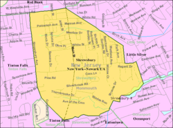
 Census Bureau map of Shrewsbury, New Jersey |
|
| Coordinates: 40°19′34″N 74°03′35″W / 40.326064°N 74.059667°WCoordinates: 40°19′34″N 74°03′35″W / 40.326064°N 74.059667°W | |
| Country |
|
| State |
|
| County | Monmouth |
| Incorporated | May 11, 1926 |
| Named for | Shrewsbury, England |
| Government | |
| • Type | Borough |
| • Body | Borough Council |
| • Mayor | Donald W. Burden (R, term ends December 31, 2018) |
| • Administrator | Thomas X. Seaman |
| • Clerk | Kathleen P. Krueger |
| Area | |
| • Total | 2.200 sq mi (5.697 km2) |
| • Land | 2.168 sq mi (5.614 km2) |
| • Water | 0.032 sq mi (0.083 km2) 1.45% |
| Area rank | 394th of 566 in state 27th of 53 in county |
| Elevation | 39 ft (12 m) |
| Population (2010 Census) | |
| • Total | 3,809 |
| • Estimate (2015) | 4,131 |
| • Rank | 423rd of 566 in state 38th of 53 in county |
| • Density | 1,757.2/sq mi (678.5/km2) |
| • Density rank | 307th of 566 in state 38th of 53 in county |
| Time zone | Eastern (EST) (UTC-5) |
| • Summer (DST) | Eastern (EDT) (UTC-4) |
| ZIP code | 07702 |
| Area code(s) | 732 |
| FIPS code | 3402567350 |
| GNIS feature ID | 0885395 |
| Website | www |
Shrewsbury is a borough in Monmouth County, New Jersey, USA. As of the 2010 United States Census, the borough's population was 3,809, reflecting an increase of 219 (+6.1%) from the 3,590 counted in the 2000 Census, which had in turn increased by 494 (+16.0%) from the 3,096 counted in the 1990 Census.
Shrewsbury was formed as a borough by an act of the New Jersey Legislature on March 22, 1926, from portions of Shrewsbury Township, based on the results of a referendum held on May 11, 1926. The borough's name comes from Shrewsbury, England.
According to the United States Census Bureau, Shrewsbury borough had a total area of 2.200 square miles (5.697 km2), including 2.168 square miles (5.614 km2) of land and 0.032 square miles (0.083 km2) of water (1.45%).
The borough borders the Monmouth County municipalities of Eatontown, Little Silver, Oceanport, Red Bank, Shrewsbury Township and Tinton Falls, all in Monmouth County.
Shrewsbury Borough prior to 1926 was a part of Shrewsbury Township, which was much larger in the past and had encompassed several of the other municipalities nearby.
As of the 2010 United States Census, there were 3,809 people, 1,261 households, and 1,026 families residing in the borough. The population density was 1,757.2 per square mile (678.5/km2). There were 1,310 housing units at an average density of 604.4 per square mile (233.4/km2). The racial makeup of the borough was 95.62% (3,642) White, 0.66% (25) Black or African American, 0.11% (4) Native American, 2.13% (81) Asian, 0.03% (1) Pacific Islander, 0.58% (22) from other races, and 0.89% (34) from two or more races. Hispanic or Latino of any race were 2.49% (95) of the population.
...
Wikipedia
