Tinton Falls, New Jersey
| Tinton Falls, New Jersey | |
|---|---|
| Borough | |
| Borough of Tinton Falls | |

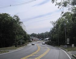
Center of Tinton Falls
|
|
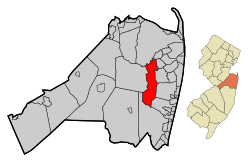
 Map of Tinton Falls in Monmouth County. Inset: Location of Monmouth County highlighted in the State of New Jersey. |
|
 Census Bureau map of Tinton Falls, New Jersey |
|
| Coordinates: 40°16′01″N 74°05′56″W / 40.267°N 74.099°WCoordinates: 40°16′01″N 74°05′56″W / 40.267°N 74.099°W | |
| Country |
|
| State |
|
| County | Monmouth |
| Incorporated | August 15, 1950 as New Shrewsbury |
| Renamed | 1975 as Tinton Falls |
| Government | |
| • Type | Faulkner Act (Mayor-Council) |
| • Body | Borough Council |
| • Mayor | Gerald M. Turning (term ends December 31, 2017) |
| • Administrator | Michael Muscillo |
| • Clerk | Maureen L. Murphy |
| Area | |
| • Total | 15.623 sq mi (40.463 km2) |
| • Land | 15.487 sq mi (40.110 km2) |
| • Water | 0.136 sq mi (0.352 km2) 0.87% |
| Area rank | 173rd of 566 in state 12th of 53 in county |
| Elevation | 98 ft (30 m) |
| Population (2010 Census) | |
| • Total | 17,892 |
| • Estimate (2015) | 17,772 |
| • Rank | 144th of 566 in state 12th of 53 in county |
| • Density | 1,155.3/sq mi (446.1/km2) |
| • Density rank | 361st of 566 in state 44th of 53 in county |
| Time zone | Eastern (EST) (UTC-5) |
| • Summer (DST) | Eastern (EDT) (UTC-4) |
| ZIP codes | 07701, 07712, 07724, 07727, 07753 |
| Area code(s) | 732 |
| FIPS code | 3402573020 |
| GNIS feature ID | 0885419 |
| Website | www |
Tinton Falls is a borough in Monmouth County, New Jersey, United States. As of the 2010 United States Census, the borough's population was 17,892, an increase of 2,839 (+18.9%) from the 15,053 counted in the 2000 Census, which had in turn increased by 2,692 (+21.8%) from the 12,361 counted in the 1990 Census.
The borough was formed as New Shrewsbury by an act of the New Jersey Legislature on August 15, 1950, based on the results of a referendum held on July 18, 1950, after breaking away from Shrewsbury Township. It was renamed "Tinton Falls" in 1975, to avoid postal errors. The name came from Lewis Morris's plantation, Tinton Manor, which employed free white workers and slaves. The borough is home to the highest waterfall on New Jersey's coastal plain.
The area that is now known as Tinton Falls was originally settled in the late 1600s, probably beginning with the initial land purchases from the Lenni Lenape Native Americans in 1664.Water power and iron ore were likely the incentives that encouraged settlement: shortly after [the land was purchased], a man by the name of James Grover had an ironworks built along the river. Grover was likely the founder of the community, which, in the 1600s, was named "New Shrewsbury". At this time, the waterfall was known to be about 30 feet (9.1 m) high; erosion and the destruction of the dam near the ironworks have led to its diminishment.
Grover's ironworks was the central fixture of the community, and it was one of the oldest built in the country, predated only by buildings in Jamestown and Massachusetts. In 1675, a half-interest in the ironworks company was purchased by Colonel Lewis Morris, [who obtained a title granting him 3,540 acres (14.3 km2) along the Shrewsbury River]. Morris also obtained land owned by Bartholomew Applegate, who had built a corn mill on the other side of the river. Morris, who procured the land for iron mining, named his holdings "Tintern Manor," after his family lands in Monmouthshire, England.Tintern Abbey, located in Monmouthshire, Wales, is often accepted as the namesake of Tinton Falls.
...
Wikipedia
